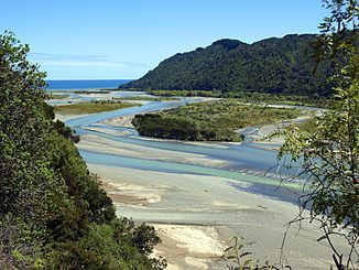
Motu River
| Motu River | ||
|
Estuary of the Motu River |
||
| Data | ||
| location | North Island (New Zealand) | |
| River system | Motu River | |
| muzzle | in the Bay of Plenty Coordinates: 37 ° 51 ′ 0 ″ S , 177 ° 35 ′ 0 ″ E 37 ° 51 ′ 0 ″ S , 177 ° 35 ′ 0 ″ E
|
|
| length | 147 km | |
| Catchment area | 1393 km² | |
The Motu River is a 147 km long river in the east of the Bay of Plenty region on the North Island of New Zealand .
geography
The Motu River rises on the slopes of the Maungahaumi on the south side of the Raukumara Range south of Opotiki . It runs eastwards, cuts through the mountain range and receives several tributaries, which increase its water catchment area to a total of 1,193 km 2 . Finally trending north, the river flows into the Pacific Ocean in the Bay of Plenty .
Name meaning
The Māori name of the river Mōtu means "cut off" or "isolated". This refers to the upper reaches, mostly uninhabited hill country, which is very steep and covered with dense rainforest until today.
use
The river is particularly used for adventure tourism such as jet boating and rafting . A proposal from the middle of the 20th century to dam the river to generate electricity was rejected. In 1984, the Motu River was the first body of water to be protected by a National Water Conservation Order under the Water and Soil Conservation Act 1967 .
Individual evidence
- ^ A b Deborah J. Ballantine, Rob J. Davies-Colley: Recommendations for water quality monitoring of a new dairying area - Upper Motu Catchment . In: National Institute of Water & Atmospheric Research (Ed.): NIWA Client Report . HAM2009-168. Hamilton November 2009 (English, Online [PDF; 1.6 MB ; accessed on February 16, 2016]).
