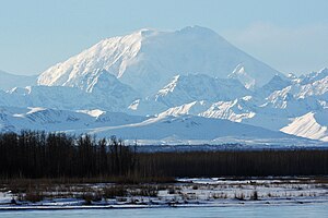
Mount Foraker
| Mount Foraker | ||
|---|---|---|
|
Mount Foraker |
||
| height | 5304 m | |
| location | Alaska (USA) | |
| Mountains | Alaska chain | |
| Dominance | 22.78 km → Denali (Archdeacons Tower) | |
| Notch height | 2195 m ↓ (3109 m) | |
| Coordinates | 62 ° 57 '37 " N , 151 ° 23' 59" W | |
|
|
||
| First ascent | August 6, 1934 by Charles S. Houston, T. Graham Brown, Chychele Waterston | |
The Mount Foraker in Denali National Park with an altitude of 5304 m the second highest peak of the Alaska Range and the third highest in Alaska (USA). It is located 23 km west-southwest of Denali (formerly Mount McKinley ).
The mountain was named in 1899 by Lieutenant JS Herron, who named it after Joseph B. Foraker, US Senator from Ohio .
On the eastern flank of Mount Foraker, the Kahiltna Glacier flows south. Foraker and Herron glaciers drain the mountain range to the north, the Lacuna glacier to the south.
Main and sub peaks
All surrounding peaks with a notch height of less than 500 meters are counted as part of the Mount Foraker massif :
| summit | height | Notch height | Coordinates |
|---|---|---|---|
| Main summit | 5304 m | 2195 m | 62 ° 58 ′ N , 151 ° 24 ′ W. |
| South summit | 5124 m | 64 m | 62 ° 57 ′ N , 151 ° 25 ′ W. |
| Southwest summit | 5029 m | 61 m | 62 ° 57 ' N , 151 ° 26' W. |
| Northwest Summit | 4581 m | 39 m | 62 ° 58 ′ N , 151 ° 26 ′ W. |
Ascent history
The first ascent was made by Charles S. Houston, T. Graham Brown and Chychele Waterston over the northwest ridge. On August 6, 1934, they climbed the main summit, four days later on August 10, 1934, the lower southern summit.
Web links
- Bivouac.com about Mount Foraker (English)
Individual evidence
- ↑ a b c Mount Foraker in the Geographic Names Information System of the United States Geological Survey
- ↑ a b c summitpost.org
- ↑ Mount Foraker, Alaska on Peakbagger.com (English)

