Mount Kaguyak
| Mount Kaguyak | ||
|---|---|---|
|
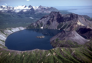
Caldera of Mount Kaguyak |
||
| height | 901 m | |
| location | Alaska Peninsula ( USA ) | |
| Mountains | Aleutian chain | |
| Coordinates | 58 ° 36 '29 " N , 154 ° 1' 41" W | |
|
|
||
| Type | Stratovolcano | |
| Last eruption | ~ 5800 BP | |
The mount kaguyak is a 901 m high stratovolcano in the Aleutian Range on the Alaska Peninsula . It is located in the northeast of the Katmai National Park .
Based on a radiocarbon date is the last to caldera -forming eruption 5,800 years back. The crater lake, 550 m below the highest point of the crater rim, has a diameter of 2.5 km and a depth of over 180 m.
Individual evidence
- ↑ a b Explosive eruptive record in the Katmai region, Alaska Peninsula: an overview from March 2007
Web links
Commons : Mount Kaguyak - collection of images, videos and audio files
- Mount Kaguyak in the Global Volcanism Program of the Smithsonian Institution (English)
- Description of Mount Kaguyak (Alaska Volcano Observatory) (English)

