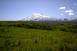
Mount Peulik
| Mount Peulik | ||
|---|---|---|
|
Mount Peulik from the north |
||
| height | 1474 m | |
| location | Alaska , USA | |
| Mountains | Aleutian chain | |
| Coordinates | 57 ° 45 '4 " N , 156 ° 22' 5" W | |
|
|
||
| Type | Stratovolcano | |
| Last eruption | 1814 | |
|
Ugashik Caldera, aerial view, looking south-west |
||
Mount Peulik , also Ugashik-Peulik, is a stratovolcano on the Alaska Peninsula in the US state of Alaska .
It is located as part of the Aleutian chain south of Becharof Lake in the Lake and Peninsula Borough north of the Ugashik Caldera and is 1474 m high. Its last eruption occurred in 1814.
Web links
Commons : Ugashik-Peulik - collection of pictures, videos and audio files
- Ugashik-Peulik in the Global Volcanism Program of the Smithsonian Institution (English)
- Volcanoes of the Alaska Peninsula and Aleutian Islands - with link to photos
- Alaska Volcano Observatory


