
Mount St. Augustine
| Mount St. Augustine | ||
|---|---|---|
 Mount St. Augustine (January 24, 2006) |
||
| height | 1260 m | |
| location | Augustine Island , Alaska , United States | |
| Coordinates | 59 ° 21 '47 " N , 153 ° 25' 50" W | |
|
||
| Type | Lava dome | |
| Last eruption | 2006 | |

The Augustine Volcano is a 1,252 meter high active volcano in the Chigmit Mountains of the Aleutian Range on Augustine Iceland , an uninhabited volcanic island off the southern coast of Alaska in the driveway of the Cook Inlet 284 km southwest of Anchorage .
description
It consists of several overlapping lava domes and is the most active volcano in the Aleutian Islands .
The flanks are covered with ash and debris from the many pyroclastic flows. The oldest dated deposits are 40,000 years old. At least 11 large rock fragments have reached the coast in the past 1800 to 2000 years.
Eruptions
Historical eruptions were mostly explosive and resulted in pyroclastic currents. Large outbreaks are known from the following years:
- around 1650, 1812, October 1883, March 13 to August 18, 1935,
- October 11, 1963 to August 19, 1964,
- 7th to 18th October 1971,
- January 1976 to May 1977 (output of 65 million m³ lava and 150 million m³ tephra ),
- March 27 to August 31, 1986 (emission of 100 million m³ tephra),
- 11 January to April 2006 (explosive eruptions with weak tremors, pyroclastic flows, phreatic explosions, lava flows and lahars. - 30 million m³ per eruption, up to 15 km altitude).

Mount St. Augustine (1986)

Mount St. Augustine (January 12, 2006)
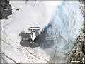
Satellite image of Mount St. Augustine


Web links
- Mount St. Augustine in the Global Volcanism Program of the Smithsonian Institution (English)
- Alaska volcano observatory (English)
- Webcam Augustine, AVO