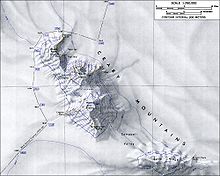
Mount Steere
| Mount Steere | ||
|---|---|---|
| height | 3558 m | |
| location | Marie Byrd Land , West Antarctica | |
| Mountains | Crary Mountains | |
| Coordinates | 76 ° 44 ′ 0 ″ S , 117 ° 49 ′ 0 ″ W | |
|
|
||
| Type | Shield volcano , extinct | |
The Mount Steere is an extinct shield volcano in the Crary Mountains of the West Antarctic Marie Byrd lands . With a height of 3558 m and an age of around 8.5 million years, it is the second highest and second oldest mountain in the range. It rises 6.4 km north-northwest of Mount Frakes .
The United States Geological Survey mapped it based on its own measurements and aerial photographs of the United States Navy from 1959 to 1966. The Advisory Committee on Antarctic Names (ACAN) named it in 1967 after the biologist William C. Steere (1907-1989), the worked on the McMurdo station from 1964 to 1965 .
Web links
- Mount Steere in the Geographic Names Information System of the United States Geological Survey .
- Skiing the Pacific Ring of Fire and Beyond: Mount Steere. In: skimountaineer.com. Amar Andalkar (English).
Individual evidence
- ↑ Kurt S. Panter et al .: Geochemistry of Late Cenozoic basalts from the Crary Mountains: characterization of mantle sources in Marie Byrd Land, Antarctica . In: Chemical Geology . tape 165 , no. 3-4 , April 2000, ISSN 0009-2541 , pp. 215–241 , doi : 10.1016 / S0009-2541 (99) 00171-0 (English, freely available online through researchgate.net ).


