
Marie Byrd Land

The Marie Byrd Land (aka Byrd Land ) is a part of West Antarctica .
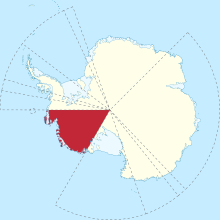
Marie-Byrd-Land, which lies on the northern edge of the West Antarctic Rift System, is to the east of the Ross Ice Shelf and the Ross Sea (between 158 ° W and 103 ° 24 ′ W). The region shows volcanic activity. There are a total of 23 large volcanoes in the area, two important ones being Mount Murphy and Mount Takahe . The also counting Mount Sidley is with 4181 m is the highest local elevation.
The American Antarctic explorer Richard Evelyn Byrd explored this part of Antarctica, which he named after his wife, during the Byrd Antarctic Expedition in 1929. His geographic exploration was carried out on Byrd's second expedition (1933-1935) and the US Antarctic Service Expedition (1939-1941). In January 1902, the Edward VII Peninsula in the northwest was discovered.
The Marie-Byrd-Land is considered to be the largest no man's land in the world. Along with Bir Tawil in Africa , it is one of two areas in the world that neither have their own administrative structure, nor are they claimed by any other state. However, this only applies to most of Marie Byrd Land - the coastal strip between 150 ° West and the Ross Sea and Ice Shelf is claimed as part of the Ross Dependency of New Zealand.
Web links
Coordinates: 75 ° 0 ′ 0 ″ S , 125 ° 0 ′ 0 ″ W.