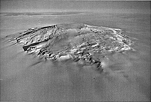
Mount Takahe
| Mount Takahe | ||
|---|---|---|
| height | 3460 m | |
| location | Marie Byrd Land , West Antarctica | |
| Coordinates | 76 ° 17 ′ 0 ″ S , 112 ° 5 ′ 0 ″ W | |
|
|
||
| Type | Shield volcano , dormant | |
The Mount Takahe is an inactive shield volcano in Marie Byrd Land in West Antarctica . On its western slope, the Cadenazzi Rock rises 2.5 km east of Roper Point .
The isolated mountain massif with a volume of 780 km³ is geologically very young; the oldest dated rocks are 310,000 years old. The volcano's most recent eruptions are believed to have occurred around 5550 BC. Analyzed rock samples from the 3460 m high Mount Takahe consisted of basanite , benmoreit , mugearite , hawaiite and trachyte .
The mountain was probably among those that the American polar explorer Richard Evelyn Byrd discovered during overflights during the United States Antarctic Service Expedition (1939-1941) in February 1940.
The volcano, which is called like a New Zealand bird , got its name in December 1957 from the members of a research group. "Takahe" was the nickname of the LC-47 , an aircraft of the US Navy , which supplied the group near the mountain with supplies and enabled aerial reconnaissance to identify possible routes.
Web links
- Takahe in the Global Volcanism Program of the Smithsonian Institution (English)
- Skiing the Pacific Ring of Fire and Beyond: Mount Takahe. In: skimountaineer.com. Amar Andalkar (English).
- Mount Takahe in the Geographic Names Information System of the United States Geological Survey (English)
- Mount Takahe on geographic.org (English)


