Cadenazzi skirt
| Cadenazzi skirt | ||
|---|---|---|
|
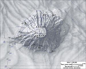
Topographic map of Mount Takahe with the Cadenazzi Rock (left) |
||
| location | Marie Byrd Land , West Antarctica | |
| Mountains | Mount Takahe massif | |
| Coordinates | 76 ° 18 ′ 0 ″ S , 112 ° 39 ′ 0 ″ W | |
|
|
||
The Cadenazzi Rock is a rock formation in Marie Byrd Land, West Antarctica . On the western slope of Mount Takahe it rises 2.5 km east of Roper Point .
The United States Geological Survey mapped it based on its own measurements and aerial photographs of the United States Navy from 1959 to 1966. The Advisory Committee on Antarctic Names named it in 1975 after Michael P. Cadenazzi (* 1947), pilot of a Sikorsky S-58 for the transport of troops as part of the United States Antarctic Research Program in the Antarctic summer campaigns between 1969 and 1970 and from 1970 to 1971.
Web links
- Cadenazzi rock in the Geographic Names Information System of the United States Geological Survey (English)
- Cadenazzi Rock on geographic.org (English)

