Mount Murphy
| Mount Murphy | ||
|---|---|---|
| height | 2703 m | |
| location | Marie Byrd Land , West Antarctica | |
| Coordinates | 75 ° 18 ′ 0 ″ S , 110 ° 42 ′ 0 ″ W | |
|
|
||
| Type | Shield volcano , extinct | |
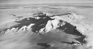
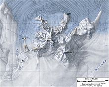
The Mount Murphy is an extinct shield volcano near the Walgreen Coast of the West Antarctic Marie Byrd lands . It is a massive, ice-capped mountain with steep, rocky slopes and looms south of the Bear Peninsula . The mountain is surrounded and partially covered by the Smith , Pope and Haynes glaciers .
The volcano was formed in the late Miocene , around 8 million years ago. Volcanic eruptions on Mount Murphy also occurred in the Pleistocene , as evidenced by the dating of one of the flank volcanoes to an age of 0.9 million years. Analyzed rock samples show the composition of the volcano. Accordingly, it consists of alkali basalt , benmoreit and trachyte .
Participants in the US American Operation Highjump (1946–1947) discovered it in January 1947. The aerial photographs taken were later used for mapping. The Advisory Committee on Antarctic Names named him in 1955 after the American ornithologist Robert Cushman Murphy (1887-1973) from the American Museum of Natural History , an expert on the Antarctic and sub-Antarctic bird life.
Web links
- Murphy in the Global Volcanism Program at the Smithsonian Institution .
- Skiing the Pacific Ring of Fire and Beyond: Mount Murphy. In: skimountaineer.com. Amar Andalkar (English).
Individual evidence
- ↑ Lucia Sala Simian: Literature Review (Anta 502): The volcanoes of Marie Byrd Land and their importance in understanding the tectonics of West Antarctica as well as the reconstruction of the West Antarctic ice sheet (WAIS) in the last interglacial. (PDF; 123 kB) Graduate Course in Antarctic Studies 2004–2005. University of Canterbury , January 10, 2005, accessed August 24, 2017 .


