
Murō-ji


Murō-ji ( Japanese 室 生 寺 ) is an old temple of Shingon Buddhism . It is located in the Uda City area in the mountains at the southern end of Nara Prefecture . Since, in contrast to most of the temples of his time, he also accepted women, he is also called the " Kōya of women" ( 女人 高 野 , Nyonin Kōya ).
Overview
The Murō-ji takes its name from the Murō volcano chain . There are many caves that have long attracted believers. Nothing is known precisely about the origins of the temple. According to the tradition of the temple, it is said to have been founded by En no Gyōja at the request of Emperor Temmu in 681 . However, it is more likely that the founding falls in the Hōki era (770-781), when the then Crown Prince and later Emperor Kammu fell ill and five priests prayed for recovery in this area. After that, Kenkyō ( 賢 憬 ; 714-793), important priest of Kōfuku-ji , built the temple. His student Shūen ( 修 円 ; 771-835) then worked at the beginning of the Heian period and completed the system. Shūen was then as important as Kōbō Daishi and Denkyō Daishi .
In the Edo period , Tokugawa Tsunayoshi promoted the temple so that it could break away from the Kofuku-ji and establish its own direction for Shigon. This also integrated the worship of the dragon god ( 龍王 , Ryūō ), who was worshiped by the rural population in a nearby cave as a helper in periods of drought. From the beginning the temple was open to women.
The attachment
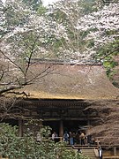
You cross a drum bridge that allows access over the narrow Murō River and pass the Outer Gate ( Omote-mon ). Behind it are the monks' quarters, further to the right you pass the Niō gate, designed as a Rōmon . The original gate from the Genroku era was missing long after a fire; it was replaced by a replica in 1965. Behind it is a small shrine for Benzaiten . You now climb a stone staircase on the Yoroi slope ( 鎧 坂 , Yoroisaka ), which is bordered by bushes , and then you have the following buildings in front of you.
building
( ⦿ = national treasure , ◎ = important cultural asset of Japan )
- ◎ Mirokudō ( 弥勒 堂 ), a building from the Kamakura period , contains various Buddhist sculptures, including a standing ◎ Miroku and a seated ⦿ Shaka Nyorai , both made of wood.
- ⦿ Kondō ( 金堂 ), from the Heian period, is laid out on the mountainside. A number of Buddhist figures (all ◎ ) with a standing ⦿ Shaka Nyorai in the middle are set up. In front of it - smaller - the twelve Heavenly Generals ( 十二 神 将 , Jūni shinshō ) are placed. Behind the sculptures there is a colored ⦿ mandala ( 帝 釈 天 曼荼羅 図 ) with the Taishaku-ten painted on Hinoki boards .
- ⦿ Hondō ( 本 堂 ), has a roof in the shape of Irimoya , which is covered with Hinoki bark, and which ends in a strongly curved canopy. The building is also called Kanjōdō ( 潅 頂 堂 ), after the Kanjō ceremony, which is important in Shingon. It comes from the Kamakura period. There is a ◎ Nyoirin Kannon wooden figure ( 如意輪観音 set). Next to the building is a larger tomb, which is decorated with a Gorintō and Kitabatake Chikafusa (1293-1354) is attributed.
- ⦿ The five-story, red-painted pagoda is only 16.1 m high and has a square floor plan of 2.45 m. This makes it the smallest outdoor pagoda of this type. The upward decrease in width is extremely small. The roofs are covered with Hinoki bark ( 檜 皮 葺 , hiwadabuki ). Like the Kondō, the pagoda is dated to the Heian period. Next to the pagoda is Shuen's tomb.
Oku no in
Behind the pagoda, a longer path, half of which is a staircase, leads to the complex called “rear property” ( の 院 , Oku no in ) on a hill .
- ◎ Mieidō ( 御 影 堂 ) is the name of the small building in the center. It has a square plan ( 単 層 宝 形 造 , tansō hōgyō-zukuri ), covered with narrow boards and crowned with stone (Stein 盤 , rōban ).
photos
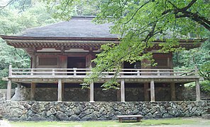
Kondo
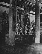
Inside the Kondō
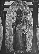
Shaka Nyorai (Kondō)
Hondō
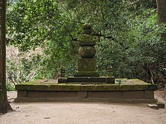
Gorintō (Kitabatake's tomb)

Mieidō


literature
- Daihonzan Murōji (Ed.): Murōji . Temple brochure, 26 pp.
- Nara-ken rekishi gakkai (Ed.): Nara-ken no rekishi sampo . Yamakawa Shuppan 1997, ISBN 4-634-29590-3 .
Web links
- Murō-ji website (Japanese)
Coordinates: 34 ° 32 ′ 17 " N , 136 ° 2 ′ 26" E