Murray Bridge Rural City
| Rural City of Murray Bridge | |
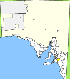
 Location of the Murray Bridge Rural City in South Australia |
|
| structure | |
| State : |
|
| State : |
|
| Administrative headquarters: | Murray Bridge |
| Dates and numbers | |
| Area : | 1,828 km² |
| Residents : | 20,858 (2016) |
| Population density : | 11 inhabitants per km² |
| Wards : | 3 |
Coordinates: 35 ° 7 ′ S , 139 ° 16 ′ E The Rural City of Murray Bridge is a local government area (LGA) in the Australian state of South Australia . The area is 1,828 km² and has about 21,000 inhabitants (2016).
Murray Bridge is located in the Murray Lands at the confluence of the Murray River with Lake Alexandrina. The area borders the metropolitan area of Adelaide and is about 65 km west of the city center. The LGA comprises 52 districts and localities: Avoca Dell, Brinkley, Burdett, Callington (East), Caloote, Chapman Bore, Ettrick, Gifford Hill, Glen Lossie, Greenbanks, Jaensch Beach, Jervois, Jury's Beach, Kepa, Long Flat, Long Flat , Long Island, Mobilong, Monarto, Monarto South, Monteith (Flat), Mulgundawa, Murrawong, Murray Bridge , Murray Bridge East, Murray Bridge North, Murray Bridge South, Murray Bridge West, Mypolonga, Nalpa, Naturi, Northern Heights, Pallamana, Riverglades, Riverglen, Rockleigh, Rocky Gully, Sunnyside, Swanport, Tavistock, Tepko, The Point, Toora, Wall Flat, Wall Flat, Wellington, Wellington (West), White Hill, White Sands, Willowbanks, Woodlane and Woods Point. The administrative headquarters of the council is in the city of Murray Bridge in the northwest of the LGA, which has about 17,000 inhabitants (2016).
administration
The Murray Bridge Council has ten members, nine councilors are elected by the residents of the three wards (three each from Brinkley, Mobilong and Monarto Ward). These three districts are defined independently of the localities. The council chairman and mayor is also elected by all residents of the LGA.
Web links
- Murray Bridge City Council website (English)
- id.com.au: Rural City of Murray Bridge Community Profile (English)
Individual evidence
- ^ Australian Bureau of Statistics : Murray Bridge (RC) (Local Government Area) ( English ) In: 2016 Census QuickStats . June 27, 2017. Retrieved April 20, 2020.
- ^ Australian Bureau of Statistics : Murray Bridge (Urban Center / Locality) ( English ) In: 2016 Census QuickStats . June 27, 2017. Retrieved April 20, 2020.