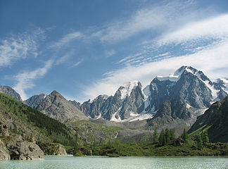
Northern Chuja ridge
| Northern Chuja ridge | ||
|---|---|---|
|
Upper Shawla Lake, in the background the Northern Chuja Ridge |
||
| Highest peak | Maascheibasch ( 4173 m ) | |
| location | Altai Republic ( Russia ) | |
| part of | Altai Mountains | |
|
|
||
| Coordinates | 50 ° 4 ′ N , 87 ° 35 ′ E | |
| rock | Slate , sandstone , limestone , metamorphic rock | |
The Northern Chuya-comb ( Russian Северо-Чуйский хребет ) is a mountain range in the Russian Republic of Altai in the central Altai Mountains .
The Northern Chuja Ridge runs in a west-east direction between the river valleys of Chuja in the north and Karagem and Chaganusun in the south. The mountain range has a length of about 120 km. The highest point is the 4173 m high peak Maascheibasch (Маашейбаш). The glacier area is given as 130 km². The mountain range consists of slate , sandstone , limestone and metamorphic rock . It has a strongly structured relief. The mountain slopes at altitudes between 2200 and 2400 m are covered by larch and Siberian stone pines - taiga . Above it there is alpine flora and tundra.
Mountains (selection)
- Maascheibasch (Маашейбаш) ( 4173 m )
- Aktru (Актру) ( 4044 m )
Web links
Individual evidence
- ↑ a b c d e Article Northern Chuja Crest in the Great Soviet Encyclopedia (BSE) , 3rd edition 1969–1978 (Russian)

