
Nagelfluh outcrop south-east of Bad Grönenbach

The Nagelfluh outcrop southeast of Bad Grönenbach , in the district of Unterallgäu ( Bavaria ) is a registered geotope with the number 778A007 in the area of the municipality of Bad Grönenbach . The outcrop is located on an eastern slope at an altitude of 732 m above sea level. NN and lies in the natural area of the Illervorberge in the geological spatial unit of the Iller- Lech region.
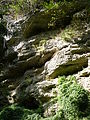
The artificially created Nagelfluh outcrop was created by mining gravel from the Lower Pleistocene . As a terrace edge, it opens up the structure of the Grönenbach gravel. Consisting of an approximately 2 meter high, diagonally layered layer of coarse material, over an approximately 1 to 2 meter high bank with a refinement of coarse gravel , it ends at the top with fine sand deposits. These deposits are documented as an overgrown river system in the glacier foreland.
The outcrop is 40 meters long, 20 meters wide and 15 meters high and covers an area of 800 square meters . The geotope is freely accessible and is classified by the Bavarian State Office for the Environment as an excursion, research and teaching object. It is considered to be of geoscientific importance and is rare in the region, but often found nationwide.

Detail of the Nagelfluh outcrop
Detail of the Nagelfluh outcrop


Individual evidence
- ^ Entry in the geotope register of the Bavarian State Office for the Environment
Web links
Coordinates: 47 ° 52 '12 " N , 10 ° 14' 8.7" E