
Nagelfluhfelsen (Ittelsburg)

The Nagelfluhfelsen near Ittelsburg is a naturally open geotope in a district of the Bad Grönenbach municipality in the Unterallgäu district ( Bavaria ). The registered geoptop bears the number 778R004 and is located at an altitude of 780 m above sea level. NN in the geological spatial unit of the Iller - Lech region. It extends over an area of around 1500 m², with a length of 50 meters, a width of 30 meters and a height of 8 meters. The historically significant outcrop shows gravel conglomerates that were deposited by meltwater from the glaciers of the Günze Age . The rubble is largely of calcareous origin. Due to the fact that only a few pieces have rounded edges and most of them are angular, it can be concluded that the material was not transported far and that the glacier front was in the immediate vicinity. The geotope is located in a landscape protection area and is classified geoscientifically significant by the Bavarian State Office for the Environment. It serves as an excursion, research and teaching object and is rare in the region and nationwide.
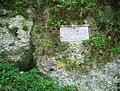
There is a memorial plaque for the German geographer and geologist Albrecht Penck at the outcrop .

Memorial plaque for Albrecht Penck (erected 1958)
Memorial plaque with surrounding rock


Individual evidence
- ^ Entry in the geotope register of the Bavarian State Office for the Environment
Web links
Coordinates: 47 ° 52 '49.7 " N , 10 ° 16'30.3" E