Nahaleg
| Nahaleg | ||
|---|---|---|
| Waters | Red Sea | |
| Archipelago | Dahlak Archipelago | |
| Geographical location | 16 ° 8 '49 " N , 40 ° 9' 37" E | |
|
|
||
| surface | 35.19 km² | |
| Highest elevation | 37 m | |
| Residents | uninhabited | |
| Nearby in the Dahlak Archipelago | ||
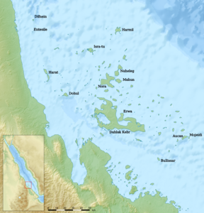
Nahaleg , as Naheleg or Nahleg transcribed, is the third largest island and the largest uninhabited island in to Eritrea belonging Dahlak archipelago in the Red Sea .
The island is about two kilometers northwest of the island of Nora . Nahaleg is a distinct double island . The slightly larger south-western part of the island has an approximately circular floor plan with a diameter of 4.8 to 5.2 km, while the northeastern neighbor resembles a triangle with rounded corners. The two sub-islands are connected by a two-kilometer-long land bridge, which at its narrowest point is barely more than 90 meters wide.
According to the PNAS island database, Nahaleg has an area of exactly 35.19 km², making it the third largest island in the archipelago after Dahlak Kebir and Nora. It reaches its maximum height of 24 meters on the southwestern part of the island, while the northeastern part is 23 meters high.
Administratively, Nahaleg belongs to the Semienawi Kayih Bahri region, like the entire Dahlak archipelago .

