Nanshi (river)
|
Nanshi 南 勢 溪 |
||
|
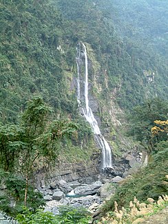
The Wulai waterfall |
||
| Data | ||
| location | Northern Taiwan | |
| River system | Tamsui | |
| Drain over | Xindian (River) → Tamsui River → Formosa Street | |
| source | District Wulai ( New Taipei City ) | |
| confluence | at Xindian (New Taipei) with the Beishi to the Xindian River Coordinates: 24 ° 54 ′ 8 ″ N , 121 ° 33 ′ 23 ″ E 24 ° 54 ′ 8 ″ N , 121 ° 33 ′ 23 ″ E
|
|
| length | 45 km | |
| Big cities | New Taipei | |
The Nanshi ( Chinese 南 勢 溪 , Pinyin Nánshìxī ) is a river in the north of the island of Taiwan . It rises in the mountains of the Wulai district of New Taipei city and flows for a length of 45 km through the Wulai and Xindian districts , where it joins the Beishi to form the Xindian River . The forested and mountainous nature on both sides of the Nanshi is scenic. The river crosses the Nandong Forest Recreation Area , which has hiking trails for visitors. A special attraction is the Wulai waterfall , which falls from a rock face on the right bank of the river .
Web links
- Water Resources Agency (Taiwan) website
- Neidong Forest Recreation Area Taiwan Forestry Bureau website
