Napranum Shire
| Shire of Napranum | |
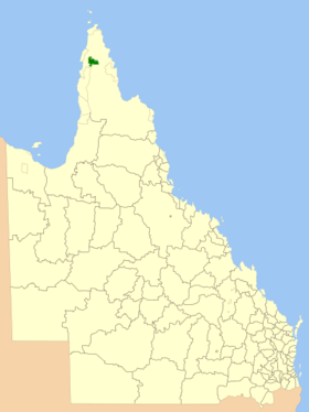
 Location of the Napranum Shire in Queensland |
|
| structure | |
| State : |
|
| State : |
|
| Administrative headquarters: | Mission River |
| Dates and numbers | |
| Area : | 2,004.4 km² |
| Residents : | 957 (2016) |
| Population density : | 0.5 inhabitants per km² |
Coordinates: 12 ° 41 ′ S , 141 ° 53 ′ E The Aboriginal Shire of Napranum is a local government area (LGA) in the Australian state of Queensland . The area is 2004 km² and has about 960 inhabitants.
geography
The Shire is located on the west coast of the Cape York Peninsula in the north of the state on the Gulf of Carpentaria about 630 km northwest of Cairns and 2020 km north of the capital Brisbane . The LGA consists of scattered individual areas around the mining town of Weipa.
All residents live in the Mission River settlement, which is located in the center of the LGA area between Weipa and Weipa Airport.
history
As early as 1898, a mission for the indigenous people was established near what is now Weipa. In 1932 this mission moved to the coast at the mouth of the Embley River. Due to the mining work in the 1960s, it was relocated to the current location of Mission River. From 1989 the Aborigines had a Community Council, which had a say in the administration of the areas they used. Since 2008 Napranum has been a Shire with limited local self-government.
administration
The Napranum Council has five members. The Mayor and four other Councilors are elected by all residents of the Shire. The LGA is not divided into electoral districts.
Web links
Individual evidence
- ↑ a b Australian Bureau of Statistics : Napranum (S) ( English ) In: 2016 Census QuickStats . June 27, 2017. Retrieved November 26, 2013.