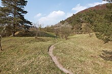
Sonnebierg nature reserve
The Sonnebierg nature reserve is located in the Luxembourg town of Helmsingen , which belongs to the municipality of Walferdingen . The 15.03 hectare area has been designated as a nature reserve since July 31, 1989 .
geology
The Sonnebierg is located on a slope on the eastern edge of the Alzette valley . This river had deep over thousands of years in, the Middle Lias attributable Luxembourg sandstone cut (li2), thus exposing the underlying layers. Stratigraphically, layers from the central Keuper (km3) form the subsoil of the Sonnebierg . These consist mainly of colorful marls with benches in between made of harder, light gray dolomite as well as individual gypsum and calcite nests . There are also layers of solid plaster of paris in various places. These formed the economic basis of the now disused Walferdinger gypsum mine . The resulting soil is reminiscent of a parched Sahelian steppe when it is dry; when it rains it is like soft soap due to the clay components . One of the main characteristics of the Sonnebierg is the numerous craters and holes that are visible all over the hill. These were created because the tunnels of the gypsum mine extend through the interior of the Sonnebierg, many of which have since collapsed.
Flora and fauna
In this nature reserve , a dry or semi-arid grassland area , up to 150 different plant species grow, including various fringed gentians , the German fringed gentian , which belongs to the genus of wreaths, and thyme . While there were 14 different orchid species in 1961 , this number had fallen to six by 1996. The reason for this was found to be the increased supply of nutrients due to increasing bush cover . As a countermeasure, the area has been grazed by a flock of sheep once or twice a year since 1991. If necessary, it can also be cleared by hand. Since then, two orchid species have returned to the home.
There are 46 different species of butterflies on the Sonnebierg, half of all in Luxembourg. The area is also an important location for grasshoppers , with 17 of them 40% of all species occurring in Luxembourg can be found. More detailed studies are also available for the spider and leafhopper species occurring in the area .
accessibility
The Sonnebierg is accessible via several footpaths, which, however, as is usual in nature reserves, must not be left. The Reimerpad hiking trail leads across the area from Walferdingen . At the upper limit of the Sonnebierg a 12-meter-high observation tower was inaugurated in 2010 by scouts from Beggen and Walferdingen.
literature
- Roland Kauffmann: Sonnebierg, or natural wealth . In: Joseph Bour (ed.): Walferdingen: history, culture, nature . Walferdingen 1993, pp. 208-209.
Web links
- Short video from 2011 on the website of the Luxemburger Wort (Luxembourgish)
- Sonnebierg nature reserve on the website of the municipality of Walferdingen
Individual evidence
- ↑ List of nature reserves in the Grand Duchy of Luxembourg ( Memento of the original of November 21, 2008 in the Internet Archive ) Info: The archive link has been inserted automatically and has not yet been checked. Please check the original and archive link according to the instructions and then remove this notice. on the environment portal of the Luxembourg government. Retrieved June 3, 2013.
- ↑ Geological map of the Grand Duchy of Luxembourg and the explanations on km3 , li2 and the gypsum deposits . Retrieved June 9, 2013.
- ↑ Walferdinger Gipsminen ( Memento of the original from February 19, 2016 in the Internet Archive ) Info: The archive link was inserted automatically and has not yet been checked. Please check the original and archive link according to the instructions and then remove this notice. on the website of the municipality Walferdingen, accessed on April 11, 2012.
- ^ Corinne Steinbach: Plan d'action Gentianella Germanica (Willd.) Börner . environnement.public.lu ( Memento of the original from September 24, 2015 in the Internet Archive ) Info: The archive link has been inserted automatically and has not yet been checked. Please check the original and archive link according to the instructions and then remove this notice. (PDF; 138 kB) Environmental portal of the Luxembourg government; accessed on June 9, 2013. (French)
- ^ Eva Hermann: The spiders (Araneae) of selected semi-arid grasslands in the east of Luxembourg . In: Bull. Soc. Nat. luxemb. , 99, 1998, pp. 189-199. snl.lu (PDF; 164 kB) accessed on June 4, 2013.
- ↑ Rolf Niedringhaus, Robert Biedermann, Herbert Nickel: Distribution atlas of the cicadas of the Grand Duchy of Luxembourg - text volume. Ferrantia, Volume 60, Luxembourg 2010. ISSN 1682-5519 . mnhn.lu (PDF; 3.7 MB) Luxembourg National Museum of Natural History; Retrieved June 7, 2013.
- ↑ brochure Reimerpad , published by the Tourism Association and funding of local government Walferdingen. Retrieved June 7, 2013.
- ↑ Armand Wagner: Nice new prospects. Luxemburger Wort, April 19, 2010. beggenerscouten.lu (PDF; 1 MB) Beggen scout; Retrieved June 7, 2013.
Coordinates: 49 ° 39 '44.8 " N , 6 ° 8' 39.9" E

