
Walferdingen
| coat of arms | map |
|---|---|

|

|
| Basic data | |
| State : |
|
| Coordinates : | 49 ° 39 ' N , 6 ° 8' E |
| Canton : | Luxembourg |
| Residents : | 8231 (January 1, 2019) |
| Area : | 7.06 km² |
| Population density : | 1166 inhabitants / km² |
| Municipality number: | 0310 |
| Website: | www.walfer.lu |
| politics | |
| Mayor: | François Sauber (CSV) |
| Elective system : | Proportional vote |
Walferdingen ( Luxembourgish Walfer , French Walferdange ) is a municipality in the Grand Duchy of Luxembourg and belongs to the canton of Luxembourg .
Composition of the community
The municipality of Walferdingen consists of the following localities:
- Bereldingen ( lux.Bareldeng )
- Helmsingen (lux. Helsem )
- Walferdingen
location
Walferdingen is located immediately north of the urban area of the state capital Luxembourg in the Alzette valley ; the villages of Walferdingen and Helmsingen are on the right of the river, Bereldingen on the left.
Historical legacy
lock

The Walferdinger Castle (Château Walferdange) was the residence of Prince Heinrich of Orange-Nassau and his wife Princess Amalia of Saxe-Weimar-Eisenach from 1853 . After the death of Prince Heinrich, the palace was assigned to Grand Duke Adolf as a residence next to the city residence by the constitution. The allocation was later changed in favor of Berg Castle. Until 2015, this former residential palace housed the Faculty of Linguistics and Literature, Humanities, Art and Education of the University of Luxembourg .
Roman evidence
In addition to a villa of Roman origin, the Roman water extraction system called "Raschpëtzer Qanat " is noteworthy. The system was built around 130 AD and maintained until around 267 AD and was used to extract water from the subsoil of the Pëtschend height and the Haedchen depression via a 600 m long subterranean tunnel and a series of vertical shafts, the lead from the mountain surface to the tunnel. By means of this tunnel system, the groundwater present in the sandstone through a layer of marl was tapped and fed to the Roman settlement about eight hundred meters away from the end of the tunnel and ninety meters below. The hitherto unique facility north of the Alps was only rediscovered in October 1986. The amount of drinking water of excellent quality is still 180 cubic meters per day.
traffic
Walferdingen is connected by the Walferdingen train station , the national road N 7 , as well as the AVL bus lines 10 and 11 and several RGTR (Régime général des transports routiers) bus routes. There is also the community bus known as “Walfy-Flexibus”.
Community partnerships
Walferdingen's partner communities are Limana in Italy, Longuyon in France and Schmitshausen in Germany.
Others
Gypsum used to be mined in a tunnel at today's Sonnebierg nature reserve ; Due to its optimal conditions, the tunnel is now used to set up and test measuring instruments for geophysical research. Opposite the Walferdingen train station is the Rosarium (" Rousegäertchen" ) , which was renovated in 2015 .
photos

Roman villa, Helmsingen

Helmsingen level crossing

View of Walferdingen
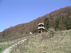
Sonnebierg nature reserve

Gallery entrance lime mine ( gypsum mines Walferdingen )


Famous pepole
- Heinrich von Oranien-Nassau (born June 13, 1820 in Soestdijk , † January 13, 1879 in Walferdingen)
- Gaston Vogel (* 1937), lawyer and author
Individual evidence
- ↑ STATEC Luxembourg - Population par canton et commune 1821–2019 (French)
- ↑ History of Walferdingen Castle ( Memento of the original from April 5, 2016 in the Internet Archive ) Info: The archive link was inserted automatically and has not yet been checked. Please check the original and archive link according to the instructions and then remove this notice.
- ↑ La villa romaine de Helmsange. ( Page no longer available , search in web archives ) Info: The link was automatically marked as defective. Please check the link according to the instructions and then remove this notice.
- ↑ Une prouesse technique de l'Antiquité. ( Memento of the original from December 23, 2015 in the Internet Archive ) Info: The archive link was inserted automatically and has not yet been checked. Please check the original and archive link according to the instructions and then remove this notice.
- ↑ Roger Infalt: The underground makes a name for itself. Day sheet. Newspaper fir Lëtzebuerg , September 30, 2003, p. 41. / Announcements from the Frontinus Society. ( Memento of the original from March 8, 2016 in the Internet Archive ) Info: The archive link was inserted automatically and has not yet been checked. Please check the original and archive link according to the instructions and then remove this notice. (PDF; 372 kB) No. 44, July / August 2003.
- ↑ 50 researchers test their gravimeters underground ( page no longer available , search in web archives ) Info: The link was automatically marked as defective. Please check the link according to the instructions and then remove this notice. Lëtzebuerger Journal , November 4, 2011
Web links
- Website of the Walferdingen community
- Walferdange on the National Tourist Board website
- La réserve naturelle sun beer: 46 sortes de papillons (video; in Luxembourgish)
Remarks
- ↑ An entry well , even Stoll bay called, is a light hole was geteuft on a cleat. These shafts are required to support the tunnel operation. (Source: Albert Serlo: Leitfaden der Bergbaukunde. First volume, fourth revised and up to the most recent edition supplemented.)