Nela (river)
| Nela | ||
|
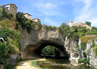
The Río Nela near Puentedey |
||
| Data | ||
| location | northern Spain | |
| River system | Ebro | |
| Drain over | Ebro → Mediterranean | |
| source |
Cantabrian Mountains 43 ° 4 ′ 35 ″ N , 3 ° 50 ′ 16 ″ W |
|
| Source height | 1000 msnm | |
| muzzle |
Ebro coordinates: 42 ° 47 '49 " N , 3 ° 23' 24" W 42 ° 47 '49 " N , 3 ° 23' 24" W. |
|
| Mouth height | 530 msnm | |
| Height difference | 470 m | |
| Bottom slope | 6.3 ‰ | |
| length | 75 km | |

The 75 km long Río Nela in the province of Burgos in the autonomous region of Castile and León is the first major tributary of the Ebro . It rises on the south side of the Cantabrian Coast Mountains near the border with the Autonomous Community of Cantabria and finally flows into the Ebro about 500 meters south of the small town of Trespaderne from the north.
places
Because of the risk of flooding after thunderstorms or continuous rain, most places on its lower reaches keep a distance of at least 200 meters. Larger places are Trespaderne, Nofuentes , Medina de Pomar , Puentedey , Pedrosa de Valdeporres
Tributaries
- Left
- Río Trueba , Río Trema, Río Engaña
right:
Attractions
In the old Castilian city of Medina de Pomar there are several historical buildings from the 13th to the 16th / 17th centuries. Century. In the village of Puentedey, the river has washed away a rock wall, creating a natural bridge.
Others
The upper reaches of the Río Nela is a good area for anglers (especially trout).
