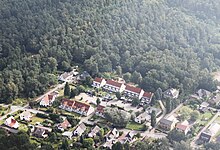
Neuenkirchener Heide
The Neuenkirchener Heide is a large forest area north-north-west of Bremen . It is mainly located in the area of the Lower Saxon community of Schwanewede , a smaller area is in the area of the Bremen district of Lüssum-Bockhorn in the northern Bremen district of Blumenthal . The name is derived from the town of Neuenkirchen , which is part of the Schwanewede community in the Osterholz district. The part belonging to Bremen, together with the adjacent forest areas in the Farge district, is the largest closed forest area both in the city of Bremen and in the entire state of the Free Hanseatic City of Bremen .
The area lies on slightly hilly Geestland and reaches a height of 25 meters above sea level in the center . NN . Coniferous forest is predominant, only in the Bremen part there are larger areas with deciduous and mixed forest stands. In the center there is a 3,000 m² but nameless lake. Parts of the Lower Saxony forest portion lying on the former training area of the German Federal Armed Forces in Schwanewede.
The Farge labor education camp was located in the Neuenkirchener Heide .
literature
- Environment planning group, Hanover: Bremen landscape program. Expert contribution to experiencing the landscape and open spaces. Part 1. Produced on behalf of the Senator for the Environment, Building, Transport and Europe, Bremen. Hannover 2011, pp. 29, 49, 68 ( online , PDF).
- Environment planning group, Hanover: Bremen landscape program. Expert contribution to experiencing the landscape and open spaces. Part 2: District-related description and evaluation. Created on behalf of the Senator for the Environment, Building, Transport and Europe, Bremen. Hannover 2011, p. 5 ( online , PDF).
Web links
Coordinates: 53 ° 12 ′ 42 " N , 8 ° 33 ′ 28" E
