Nevada State Route 225

|
|
|---|---|
| map | |

|
|
| Basic data | |
| Overall length: | 100,301 mi. / 161.42 km |
| Opening: | 1976 |
| Starting point: |
|
| End point: |
|
| County: | Elko County |
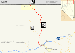
State Route 225 ( SR 225 ) is a 161.4 km long state highway in Elko County in Nevada , United States . The route, also known as the Mountain City Highway , connects Elko via Mountain City with the city of Owyhee not far from the Idaho border . The track is about the Idaho State Highway 51 with Interstate 84 connected. The route of the SR 225 lies entirely in Elko County.
Route
SR 225 begins at the intersection of SR 535 / Interstate 80 Business Loop (Idaho Street) and Silver Street, just west of central Elko. From here, the route leads northwest along the east side of Elko Regional Airport to the interstate 80 junction . The SR 225 continues to the northwest, winds through a narrow valley to the Adobe Summit in the Adobe Range . From there it follows a northerly direction, passes Dinner Station , a ghost town , and crosses the Deep Creek Highway ( SR 226 ) at Tuscarora Junction. It then heads north, past North Fork , crossing several county roads before reaching Wild Horse on the south bank of Wild Horse Reservoir . The road then winds its way along the east and north banks of the reservoir before cutting through the narrow and winding canyon of the Owyhee River . After the canyon, the valley widens and the SR 225 runs through Mountain City . Further north-west, the valley widens significantly before the line reaches Owyhee. A few miles north of Owyhee, the route reaches the Idaho state line and becomes Idaho State Highway 51 .
history
The current route of the SR 225 was composed of several sections of other routes prior to 1976, including State Route 11 , State Route 43, and State Route 51 .
Important intersections
| location | mi | km | Directions | Remarks | |
| Electrolytic capacitor |
|
||||
|
|
|||||
|
|
|||||
| Owyhee |
|
further route in Idaho | |||
| 1,000 mi = 1.609 km; 1,000 km = 0.621 mi | |||||
supporting documents
- ^ A b Nevada Department of Transportation : State Maintained Highways of Nevada: Descriptions and Maps . January 2017. Retrieved April 16, 2019.


