New York State Route 292

|
|
|---|---|
| map | |

|
|
| Basic data | |
| Overall length: | 7.58 mi. / 12.20 km |
| Opening: | 1970 |
| Starting point: |
|
| End point: |
|
| Counties: |
Putnam County Dutchess County |
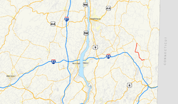
New York State Route 292 or NY 292 is a short state route in the Hudson Valley in New York , United States , which connects the Putnam and Dutchess counties. The southern end point is on New York State Route 311 in Patterson , the northern end point is on New York State Route 55 within the Town of Pawling .
Route description
State Route 292 has its starting point on New York State Route 311 near the hamlet of Patterson. It leads first to the west, south of the Patterson Veteran Memorial Park parallel to the county line between Putnam County and Dutchess County and crosses County Route 63. It crosses the hamlet of West Patterson and then turns north into Dutchess County. There it led through the Town of Pawling, where it crosses County Route 30.
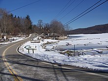
The road continues north through a rural, wooded area that is sparsely built up before turning west to run along the southern edge of Whaley Lake . At the southwestern tip of the lake, the State Route resumes its northerly direction to reach West Pawling along the western and later northern shores. There NY 292 turns east and leads for a short distance on a former route of New York State Route 55 to its end point at today's NY 55 in the northwest of the Town of Pawling.
history

Part of the State Route was once part of the Patterson-Dutchess County Line Road, a 2.59 km dirt road from Banks Corner to Whaley Lake. In 1919 plans were passed to rebuild the previously inadequate road; the cost of the project amounted to 43,500 US dollars (1919), of which 15,225 US dollars (1919) to the Putnam County. Construction of the new road began in May and was completed in November 1919.
State Route 292 was originally part of the old New York State Route 39 , which ran from Patterson via West Patterson and East Fishkill to Poughkeepsie . When renumbered in 1930, the section between East Fishkill and the western edge of Patterson was incorporated into the new New York State Route 52 . Between Patterson and the junction with New York State Route 22 , old NY 39 became New York State Route 311 .
In the late 1930s the course of NY 52 was redefined; it has since followed the current route between Stormville and Lake Carmel , the old route between Stormville and Patterson became part of New York State Route 216 . The route remained unchanged until January 1, 1970. At that time, NY 216 was shortened to its current endpoint in Poughquag . The previous section between West Pawling and Patterson was renumbered as NY 292.
See also
Web links
Individual evidence
- ↑ 2007 Traffic Data Report for New York State ( English , PDF) New York State Department of Transportation . P. 276. July 25, 2008. Retrieved February 17, 2008.
- ↑ a b Google Maps: Overview of New York State Route 292 ( English ) [Map]. 2008. Retrieved February 17, 2008.
- ↑ Historic Patterson: From Dirt Roads to the Interstate Highway ( English ) The Town of Patterson NY. Retrieved February 17, 2009.
- ^ Rand McNally Auto Road Atlas (eastern New York) ( English ) Rand McNally . 1926. Retrieved February 17, 2009.
- ^ Leon A. Dickinson: New Signs for State Highways (English) . In: New York Times , Jan 12, 1930, p. 136.
- ^ Automobile Legal Association (ALA) Automobile Green Book , 1930/31 and 1931/32 editions, (Scarborough Motor Guide Co., Boston, 1930 and 1931). The 1930/31 edition shows the course of the State Routes in New York before the renumbering.
- ^ Rand McNally: Road Map & Historical Guide - New York . Sun Oil Company , 1935.
- ^ Automobile Legal Association (ALA) Automobile Green Book , 1938/39, (WA Thibodeau, 1938).
- ↑ State of New York Department of Transportation : Official Description of Touring Routes in New York State ( English , PDF; 4.9 MB) January 1, 1970. Retrieved February 19, 2009.
