Ngwel
| Ngwel | ||
|---|---|---|
|
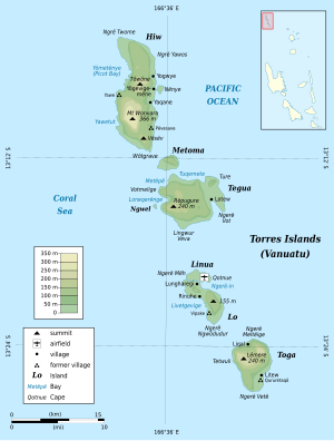
Map of the Torres Islands Ngwel in the center of the picture |
||
| Waters | Coral sea | |
| Archipelago | Torres Islands | |
| Geographical location | 13 ° 15 '8 " S , 166 ° 35' 10" O | |
|
|
||
| length | 500 m | |
| width | 200 m | |
| surface | 7 ha | |
| Highest elevation | 4 m | |
| Residents | uninhabited | |
Ngwel (in Lo-Toga [ ŋʷel ] "reef"), also called Île Mel , is a small, uninhabited island in the Pacific island nation of Vanuatu . It is located 600 meters off the west coast of the island of Tegua in the center of the Torres Islands , which politically belong to the Vanuatu province of Torba .
The island extends from north to south for almost 500 meters and is a maximum of 200 meters wide.
Web links
- Vanuatu Travel - John Seach (Eng.)

