Toga (island)
| toga | ||
|---|---|---|
|
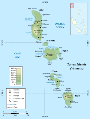
Map of the Torres Islands Toga in the picture at the bottom |
||
| Waters | Coral sea | |
| Archipelago | Torres Islands | |
| Geographical location | 13 ° 24 '59 " S , 166 ° 41' 49" E | |
|
|
||
| surface | 18.8 km² | |
| Highest elevation |
Mount Lemeura 240 m |
|
| Residents | 276 (2009) 15 inhabitants / km² |
|
| main place | Litew | |
Toga , also called South Island and (in Lo-Toga ) [ tɔɣə ], is an 18.8 km² island in the Pacific island state of Vanuatu . It is the southernmost of the Torres Islands , which politically belong to the Vanuatu province of Torba .
Toga had 276 inhabitants in 2009. The main town is Litew. The summit of Mount Lemeura reaches a height of 240 m.

