Metoma
| Metoma | ||
|---|---|---|
|
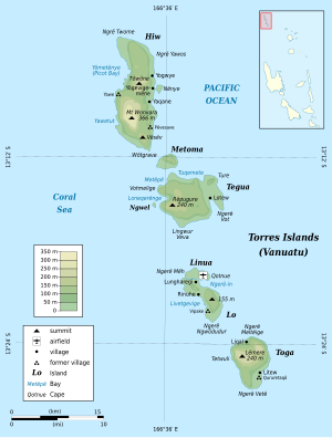
Map of the Torres Islands Metoma in the upper half of the picture |
||
| Waters | Coral sea | |
| Archipelago | Torres Islands | |
| Geographical location | 13 ° 12 '29 " S , 166 ° 36' 13" E | |
|
|
||
| surface | 3 km² | |
| Highest elevation | 115 m | |
| Residents | 13 (2009) 4.3 inhabitants / km² |
|
| main place | Rival | |
Metoma (also Ovale Island ) is a 3.0 km² island in the Pacific island state of Vanuatu .
It lies between the larger islands of Hiw and Tegua , which also belong to the Torres Islands , which politically belong to the Vanuatu province of Torba .
Metoma had 13 residents in 2009. The village in the south of the island is called Rival .
Individual evidence
- ↑ Torres Islands ( Memento of the original from December 21, 2014 in the Internet Archive ) Info: The archive link was inserted automatically and has not yet been checked. Please check the original and archive link according to the instructions and then remove this notice. (Map)

