Niederungsburg Naugarten
| Niederungsburg Naugarten | ||
|---|---|---|
|
Niederungsburg castle wall |
||
| Creation time : | 7th to 10th centuries | |
| Castle type : | Niederungsburg | |
| Conservation status: | Castle wall | |
| Place: | Naugarten | |
| Geographical location | 53 ° 18 '47 " N , 13 ° 41' 9" E | |
|
|
||
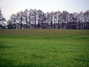
The Niederungsburg Naugarten is located as a rampart on a field directly on the shore of the Naugartener See at the eastern entrance to Naugarten, a district of the municipality of Nordwestuckermark in the Uckermark district in Brandenburg . It is a classic low castle of a Slavic rampart from the 8th to 10th centuries. The castle wall has already been badly affected by agriculture. The walls look very polished. Nevertheless, the castle complex is still clearly recognizable as such in the area. It had an oval shape over 100 meters in diameter and was one-limbed. The castle was in the tribal area of the Ukranen , who belonged to the Wilzen . There are no written records about the castle. One must therefore assume that this is the fortified retreat of the local population. The rampart was the center of a smaller settlement chamber, to which several surrounding village settlements belonged. Sometime in the 9th to 10th century the facility was abandoned. The reasons for this are unknown. Large-scale castles were probably no longer modern and the developing local nobility preferred their own smaller castles as mansions.
literature
- Volker Schmidt : Drense, a main castle of the Ukrane. German Science Publishing House, 1989
Web links
- History of Naugarten ( Memento from January 16, 2012 in the Internet Archive )

