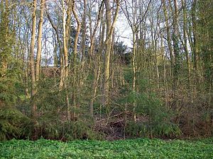
Naugarten hill fort
| Naugarten hill fort | ||
|---|---|---|
|
Castle wall Schloßberg |
||
| Alternative name (s): | Schlossberg | |
| Creation time : | 10th to 12th centuries | |
| Castle type : | Hilltop castle | |
| Conservation status: | Burgstall | |
| Place: | Naugarten | |
| Geographical location | 53 ° 18 ′ 37 " N , 13 ° 40 ′ 20" E | |
|
|
||
The Höhenburg Naugarten is located directly on the south bank of the Naugartener See in Naugarten, a district of the municipality of Nordwestuckermark in the Uckermark district in Brandenburg . It was a hill fort , a Slavic rampart built on a natural small mountain. The approximately square castle hill is a good 60 by 60 meters. This type of castle was more likely to be found in the Middle to Yugoslav period from the 10th to the 12th centuries. It will be the successor castle of lowland castle have acted. The aristocratic seat of a local Slavic locator was located on the plateau of the Schlossberg . Wall systems are not visible on the plateau. Due to the natural protective layer, simple palisades were probably sufficient for protection. The area came into German hands by 1150 at the latest, and the Schloßberg was probably abandoned as a Slavic castle. The German immigrants continued to use the Schloßberg area as a castle. The original place name of the settlement was Novo Grad , which means something like New Castle in Slavic . Possibly the Schlossberg was meant. The place was first mentioned in a document on January 1st, 1239. At that time, the manor owners Borke von Kerkows lived on the castle hill .
literature
- Volker Schmidt : Drense, a main castle of the Ukrane. German Science Publishing House, 1989
Web links
- History of Naugarten ( Memento from January 16, 2012 in the Internet Archive )

