Ninigo Islands
| Ninigo Islands | |
|---|---|
| NASA photo of the Ninigo Islands | |
| Waters | Pacific Ocean |
| Geographical location | 1 ° 16 ′ S , 144 ° 16 ′ E |
| Number of islands | 8 atolls |
| Main island | Ninigo atoll |
| Residents | 972 (2000) |
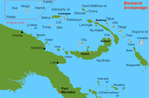
| Map of the Western Islands of the Bismarck Archipelago, with the Ninigo Islands in the center | |
The Ninigo Islands (German: Schachbrettinseln ) are a group of atolls of the western islands of the Bismarck Archipelago . Administratively, the atolls belong to the Manus Province in Papua New Guinea .
geography
The archipelago is located approx. 1000 km northeast of Papua New Guinea's capital Port Moresby and 255 km northwest of the provincial capital Manus . The group consists of the 3 larger atolls:
- Ninigo , approx. 34 km long and 18 km wide, with the main island Mal , as well as approx. 30 smaller Motus (including four inhabited: Pihon, Amik, Mal, Lau);
- Pelleluhu , approx. 9 km long and 8 km wide, with the main island Pelleluhu and 13 other motus;
- Heina , approx. 5 km northeast of Pelleluhu, consisting of 6 motus;
and the 5 smaller atolls:
| Atoll / island | Coordinates | surface | Population 2000 |
|---|---|---|---|
| Ninigo | ... | ... | 633 |
| Pelleluhu | ... | ... | - |
| Heina | ... | ... | - |
| Liot | ... | ... | 68 |
| Sama | ... | ... | 202 |
| Sumasuma | ... | ... | - |
| Awin | ... | ... | 51 |
| Manu | ... | ... | 18th |
| Ninigo Islands | ... | ... | 972 |
Individual evidence
- ↑ German Colonial Lexicon. Edited by Heinrich Schnee. - Leipzig: Quelle & Meyer 1920. - 3 vols.
Web links
- Detailed description Oceandots.Com (Engl.) ( Memento of 23 December 2010 at the Internet Archive )
- Maps of the Ninigo Group
- The Full Story of Ninigo
- The Wuvulu Web Site: Geography of the Western Islands, Geographical Names in the Western Islands (with a systematic listing of all islands in each atoll, including name variants)


