Nordenskiöld Land
| Nordenskiöld Land | ||
 View in the south of the peninsula (national park) |
||
| Geographical location | ||
|
|
||
| Coordinates | 78 ° 3 ' N , 15 ° 32' E | |
| Waters 1 | Isfjorden | |
| Waters 2 | Bellsund / Van Mijenfjorden | |
| length | 90 km | |
| width | 58 km | |
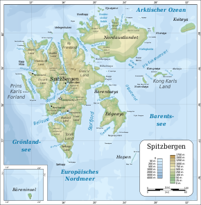
 Topographic map of Svalbard |
||
Nordenskiöld-Land is a peninsula on Svalbard . It covers the central part of the island between Isfjorden and Bellsund / Van Mijenfjorden . On the north coast of the peninsula are the largest inhabited places in Svalbard, namely Longyearbyen and Barentsburg . Isfjord Radio is located on its north-western cape, Kapp Linné . The mining settlement of Sveagruva is located on the southeast coast. The entire west coast bordering the Arctic Ocean is taken up by a flat and wide stretch of coast called Nordenskiöldkysten ( Nordenskiöld Coast ). The southern half of the peninsula is occupied by the Nordenskiöld Land National Park. In the northeast, the peninsula is still part of the Sassen-Bünsow-Land National Park . South of the Van Mijenfjorden is the Nathorst-Land peninsula .
The name appears in the maps and publications of Gerard De Geer (1896 and 1900) and Gunnar Isachsen (1915) and pays homage to Adolf Erik Nordenskiöld .
Literature and Sources
- Nordenskiöld Land . In: The Place Names of Svalbard (first edition 1942). Norsk Polarinstitutt , Oslo 2001, ISBN 82-90307-82-9 (English, Norwegian).
