
Norissteig
The Norissteig is an easy via ferrata in the Franconian Alb and a popular destination for the Nuremberg population. Noris is the allegorical name of the city of Nuremberg.

history
The Norissteig was established in 1929 by the Noris section of the German Alpine Club . It is maintained and serviced by the Noris Section. In the event of an accident, the Nuremberg mountain rescue service, which has a rescue station manned on weekends in Hirschbach (Schmiedberg hut), helps .
Location and dates

The Norissteig is marked as a route on the OpenStreetMap map.
The Norissteig is an impressive hike, well signposted with a red dot, with climbing elements. A hiking trail also runs parallel to the rock. Families often split up: the sporty and brave dare to go to the various climbing spots, while others watch them from the hiking trail. The via ferrata itself can be easily climbed with older children, for smaller children there are always small rocks and easy climbing spots on the edge. Always secure children.
Good starting points are the Hohenstadt train station , the hiking car park in Fischbrunn , the hiking car park 1 km southeast of Hirschbach or, in the opposite direction, the car park in Hirschbach.
From Hohenstadt, the 5 km long access path leads across the meadows of the Hirschbachtal in just under an hour through Eschenbach to Fischbrunn , from there in 15 minutes to the information board at the southeastern entrance to the Norissteig. The Norissteig itself leads from Fischbrunn to Mittelhirschbach. The distance is 6 km and requires a walking time of 1.5 hours. If you have climbed all the climbing areas, you can expect about 3½ to 4½ hours. Alternatively, the Norissteig can also be hiked as a circular hike, on the valley path (first number 2, then a horizontal yellow line ) back to the starting point, then the hiking time is half an hour more. The Norissteig can also be climbed in the opposite direction and then offers completely different impressions, because every ascent becomes a descent and vice versa.
difficulty
The Norissteig is classified in difficulty class A (not very difficult) .
The Bergwacht Nuremberg assesses the difficulty as follows:
- “The Norissteig is only insured very sparingly with steel pins and wire ropes, the 1st degree is consistently left as a bare climbing rock. The path leads specifically over various rock formations - above and across, in some places also below. It requires far less effort than the neighboring Höhenglücksteig . However, it should not be walked unsecured, as the rock has climbed smooth and there is an increased risk of slipping. Those with a head for heights can avoid all climbing areas. Be careful when wet! "
A via ferrata set is recommended as equipment .
Attractions
The following sights are natural monuments of Franconian Switzerland on the Norissteig hiking trail. For the via ferrata walkers, they are the actual via ferrata points.
Servant's cave
The Knechtshöhle is an accessible cave with a "window" in the middle of a vertical rock face, only accessible by easy climbing, secured with a wire rope. The entrance is through this window, the exit is higher up and is also connected with easy climbing.
Noris-Törle

The Noris-Törle is an approximately 10 meter high rock with a 2.5 meter wide and 4 meter high through hole. The rock can be climbed and offers a good view. At its foot there is a rest area that is used by many hikers. The rock bridge is registered in the Franconian Alb cave register (HFA) as Noristörle A 193 cave.
Brettl
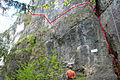
The Brettl, a 30 meter high rock face, in which a narrow ledge runs horizontally halfway up, is only suitable for those with a head for heights. In some places the band is very narrow or no longer present and replaced by steel pins embedded in the rock. The greatest horizontal distance between two steel pins is about one meter. The path is secured with a steel cable as a railing.
Castell

The Castell is a rock formation above the Brettl. The name comes from the castle-like appearance.
Spring stone
The spring stone is a deep chasm that can be overcome with one jump. The place is reached via a rock ledge secured by wire rope.
There are also sport climbing routes with difficulty levels from IV to IX + on the jump stone.
Franke chimney
The Franke chimney is a 20 meter deep chimney that is easy to walk through with good handles and kicks. Where there are no steps, it is reinforced with steel clips as a climbing aid. The chimney has been secured with wire rope since November 2012.
The Franke chimney is part of the Castellwand, which offers over 40 sport climbing routes with levels of difficulty from 3+ to 10-.
Mittelbergwand
The Mittelbergwand is 50 meters high and only suitable for those with a head for heights. It is secured with a wire rope and more difficult places are bridged with iron pins. The entrance begins with an 8 meter high chimney. This is followed by a long and exposed traverse that climbs diagonally to the left, a steep step requires some strength. The summit with the summit cross offers a wonderful view of the Hirschbach Valley.
With over 60 secured routes, the Mittelbergwand is a worthwhile destination for sport climbers with degrees of difficulty from 3 to 10-.

Mittelbergwand
Chimney and traverse

Summit cross


Web links
- Norissteig , tour description with lots of photos and GPS track on via-ferrata.de
- Norissteig as a route on the OpenStreetMap map
Coordinates: 49 ° 33 ′ 5.2 ″ N , 11 ° 31 ′ 28.2 ″ E