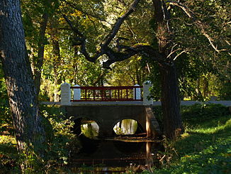
Nuutri (river)
| Nuutri | ||
| Data | ||
| location | Hiiumaa , Estonia | |
| River system | Nuutri | |
| source | Määvli moor 58 ° 56 ′ 13 ″ N , 22 ° 42 ′ 45 ″ E |
|
| muzzle |
Baltic Sea coordinates: 58 ° 56 ′ 22 " N , 22 ° 46 ′ 16" E 58 ° 56 ′ 22 " N , 22 ° 46 ′ 16" E
|
|
| length | 15.5 km | |
| Catchment area | 46 km² | |
| Medium-sized cities | Kärdla | |
| Communities | Hiiumaa | |
| Residents in the catchment area | 4000 | |
The Nuutri River ( Estonian Nuutri jõgi ) flows on the second largest Estonian island, Hiiumaa (German Dagö ).
description
The Nuutri is (with side arms) 15.5 kilometers long. Its catchment area covers 46 km².
The calm river has its source in the southern part of the Määvli moor ( Määvli raba ). It flows into the bay of Tareste ( Tareste laht ) and thus into the Baltic Sea at the beach park of the island's capital Kärdla .
The river is particularly known for its brown trout . Fishing is prohibited from mid-September to the end of January.
Web links
- Entry in the Estonian environmental register
Individual evidence
- ↑ http://kala.goto.ee/et/kalapueuek?sobi2Task=sobi2Details&sobi2Id=86 ( page no longer available , search in web archives ) Info: The link was automatically marked as defective. Please check the link according to the instructions and then remove this notice.
