Ojo de Agua (Tecámac)
| Ojo de Agua | ||
|---|---|---|
|
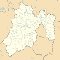
Coordinates: 19 ° 41 ′ N , 99 ° 1 ′ W Ojo de Agua on the map of Mexico
|
||
| Basic data | ||
| Country | Mexico | |
| State | México | |
| Municipio | Tecámac | |
| Residents | 348,500 (2019) | |
| Detailed data | ||
| surface | 34.2 km² | |
| height | 2250 m | |
Ojo de Agua is the largest city in the Municipio Tecámac in the Mexican state of México . It is located in the northeastern part of the state, northeast of the Federal District and in the area of the Zona Metropolitana del Valle de México . With a population of about 348,500 Ojo de Agua is the largest town in Mexico that is not a parish seat.
history
The origins of the establishment of the place go back to the Hacienda Ojo de Agua on the banks of the Xaltocan Lake. It is believed that construction began in 1585. In 1725 there was a monastery of the Dominican Order .
population
At the 2010 census, the city had a population of 255,015. The literacy (reading ability) was 98.8% of the population. 85.3% of the population were Catholics , 9.4% were Protestants and 5.1% had no religion.
Population development
| year | population |
|---|---|
| 1990 | 28,894 |
| 2000 | 74.143 |
| 2005 | 161,820 |
| 2010 | 242.272 |
| 2015 | 311.100 |
Individual evidence
- ↑ México (Mexico): State & Cities - Population Statistics, Maps, Charts, Weather, and Web Information. Retrieved February 8, 2020 .
