Municipio Tecámac
| Tecámac | ||
|---|---|---|

|
||
| Symbols | ||
|
||
| Basic data | ||
| Country | Mexico | |
| State | México | |
| Seat | Tecámac de Felipe Villanueva | |
| surface | 157.4 km² | |
| Residents | 364,579 (2010) | |
| density | 2,315.8 inhabitants per km² | |
| founding | 1825 | |
| Website | www.tecamac.gob.mx/ | |
| INEGI no. | 15081 | |
| politics | ||
| Presidente municipal | Rocio Díaz Montoya | |
| Palacio municipal of Tecámac | ||
Coordinates: 19 ° 43 ′ N , 98 ° 58 ′ W
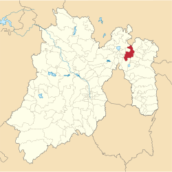
Tecámac is a municipality in the Mexican state of México . It belongs to the Zona Metropolitana del Valle de México , the metropolitan region around Mexico City . The seat of the municipality is Tecámac de Felipe Villanueva . Tecámac had 364,579 inhabitants in 2010, the area of the municipality is 137.4 km² .
geography
Tecámac is located in the north of the state of México, about 40 km north of Mexico City and 100 km northeast of Toluca de Lerdo , at an altitude of about 2300 m . About 80% of the community area is used for agriculture.
The municipality Tecámac borders on the municipalities Zumpango , Temascalapa , Teotihuacán , Acolman , Morelos , Berriozábal , Jaltenco , Tonanitla and Nextlalpan as well as the municipality Tizayuca in the state of Hidalgo .
towns and places
The municipality Tecámac comprises 45 places, six of them have at least 10,000 inhabitants, another five at least 500 inhabitants.
By far the largest city in the municipality is Ojo de Agua with over 200,000 inhabitants, the next largest towns are San Martín Azcatepec , Los Reyes Acozac , Santa María Ajoloapan , Tecámac de Felipe Villanueva , Fraccionamiento Social Progresivo Santo Tomás Chiconautla and San Pablo Tecalco .
Web links
- Enciclopedia de los Municipios y Delegaciones de México: Municipio Tecámac (Spanish)
- INEGI : Datos Geográficos: Municipio Tecámac (Spanish; PDF)


