Municipio Tepetlixpa
| Tepetlixpa | |
|---|---|

|
|
| Basic data | |
| Country | Mexico |
| State | México |
| Seat | Tepetlixpa |
| surface | 43.4 km² |
| Residents | 18,327 (2010) |
| density | 422 inhabitants per km² |
| founding | 1869 |
| Website | tepetlixpa.gob.mx |
| INEGI no. | 15094 |
| politics | |
| Presidente municipal | Jacinto Pérez Pérez |
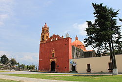
| San Esteban Church in Tepetlixpa | |
Coordinates: 19 ° 1 ′ 12 ″ N , 98 ° 49 ′ 48 ″ W.
Tepetlixpa is a municipality in the Mexican state of México . It belongs to the Zona Metropolitana del Valle de México , the metropolitan region around Mexico City . The seat of the municipality is the eponymous Tepetlixpa . At the 2010 census, the municipality had 18,327 inhabitants in 4,282 households. Almost 15% of the population lived in extreme poverty at that time. The area of the municipality amounts to 43.4 km².
geography
Tepetlixpa is located in the southeast of the state of Mexico, about 20 km southeast of the border of the federal district at an altitude of about 1600 m to 2600 m . More than 80% of the community area is used for agriculture.
The municipality of Tepetlixpa borders on the municipalities of Ozumba and Juchitepec and the state of Morelos .
places
The municipality comprises 23 localities, three of which have at least a thousand inhabitants. In addition to the main town Tepetlixpa (13,239 inhabitants), these are Nepantla de Sor Juana Inés de la Cruz and San Esteban Cuecuecuautitla .
Web links
- Enciclopedia de los Municipios y Delegaciones de México: Municipio Tepetlixpa (Spanish)
- INEGI : Datos Geográficos: Municipio Tepetlixpa (Spanish; PDF)


