Municipio Tonatico
| Tonatico | ||
|---|---|---|
| Symbols | ||
|
||
| Basic data | ||
| Country | Mexico | |
| State | México | |
| Seat | Tonatico | |
| surface | 91.7 km² | |
| Residents | 12,099 (2010) | |
| density | 131.9 inhabitants per km² | |
| founding | 1870 | |
| Website | www.tonatico.gob.mx/ | |
| INEGI no. | 15107 | |
| politics | ||
| Presidente municipal | Elodio Gordillo Méndez | |
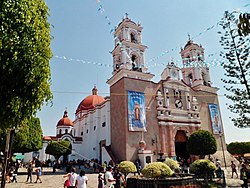
| Santuario de Nuestra Señora de Tonatico | ||
Coordinates: 18 ° 48 ′ N , 99 ° 40 ′ W
Tonatico is a municipality in the Mexican state of México . The municipality had 12,099 inhabitants and 3,214 households in 2010; 11% of the population lived in extreme poverty. The area of the municipality is 91.7 km² .
The administrative seat and largest of the 15 towns in the municipality is the Tonatico of the same name . The next larger towns in the municipality are El Terrero and La Puerta de Santiago .
geography
Tonatico is located in the south of the state of México, about 80 km southwest of Mexico City , 50 km west of Cuernavaca and 50 km south of Toluca de Lerdo at an altitude between 1440 m and 2125 m .
The municipality of Tonatico borders on the municipalities of Ixtapan de la Sal and Zumpahuacán and the state of Guerrero .
Web links
- Enciclopedia de los Municipios y Delegaciones de México: Municipio Tonatico (Spanish)
- INEGI : Datos Geográficos: Municipio Tonatico (Spanish; PDF)


