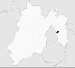
Municipio La Paz (México)
| La Paz | ||
|---|---|---|

|
||
| Symbols | ||
|
||
| Basic data | ||
| Country | Mexico | |
| State | México | |
| Seat | Los Reyes Acaquilpan | |
| surface | 36.8 km² | |
| Residents | 253,845 (2010) | |
| density | 6,903.2 inhabitants per km² | |
| founding | 1875 | |
| Website | losreyeslapaz.gob.mx | |
| INEGI no. | 15070 | |
| politics | ||
| Presidente municipal | Juan José Medina Cabrera | |
| Palacio Municipal | ||
Coordinates: 19 ° 21 ′ 40 ″ N , 98 ° 58 ′ 50 ″ W.
La Paz , also known as Los Reyes La Paz , is a municipality in the Mexican state of México . It belongs to the Zona Metropolitana del Valle de México , the metropolitan region around Mexico City .
The seat of the parish and its largest city is Los Reyes Acaquilpan . The municipality had 253,845 inhabitants in 2010, the area is 36.8 km² .
La Paz has important industrial zones.
geography
La Paz is located in the east of the state of México at over 2200 m above sea level.
The municipality of La Paz borders the municipalities Chimalhuacán , Chicoloapan , Ixtapaluca , Valle de Chalco Solidaridad and Nezahualcóyotl as well as the federal district of Mexico City .
The municipality is largely urbanized.
towns and places
The municipality comprises 18 places, 12 of which have over 5,000 inhabitants.
| Place name | Population (2010) |
|---|---|
| Los Reyes Acaquilpan | 85,359 |
| San Isidro | 33,737 |
| La Magdalena Atlicpac | 26,429 |
| Emiliano Zapata | 25,309 |
| San Sebastian Chimalpa | 12,951 |
| Lomas de San Sebastian | 12,372 |
| Professor Carlos Hank González | 10,416 |
| El Pino | 8,332 |
| San José las Palmas | 8,203 |
| Tecamachalco | 6,780 |
| Arenal | 6,700 |
| Lomas de Altavista | 5,704 |
| Unidad Acaquilpan | 4,806 |
| Bosques de la Magdalena | 2,803 |
| Techachaltitla | 1.994 |
| Lomas de San Sebastian | 1,447 |
| Colonia Máximo de la Cruz | 429 |
| Los Pirules | 74 |
Web links
- Enciclopedia de los Municipios y Delegaciones de México: Municipio La Paz (Spanish)
- INEGI : Datos Geográficos: Municipio La Paz (Spanish; PDF)


