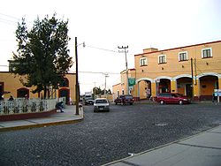
Municipio Hueypoxtla
| Hueypoxtla | ||
|---|---|---|

|
||
| Symbols | ||
|
||
| Basic data | ||
| Country | Mexico | |
| State | México | |
| Seat | Hueypoxtla | |
| surface | 235.2 km² | |
| Residents | 39,864 (2010) | |
| density | 169.5 inhabitants per km² | |
| founding | November 29, 1820 | |
| Website | www.hueypoxtla.gob.mx | |
| INEGI no. | 15036 | |
| politics | ||
| Presidente municipal | Francisco Santillán Santillán | |
| Place Hueypoxtla | ||
Coordinates: 19 ° 55 ′ N , 99 ° 3 ′ W
Hueypoxtla is a municipality in the Mexican state of México . It belongs to the Zona Metropolitana del Valle de México , the metropolitan region around Mexico City . The seat of the municipality is Hueypoxtla of the same name . The municipality had 39,864 inhabitants in 2010, its area is 235.2 km² .
geography
Hueypoxtla is located in the north of the state of México, about 50 km north of Mexico City.
The municipality borders in the north on Ajacuba and San Agustín Tlaxiaca in the state of Hidalgo , in the east on Tolcayuca (Hidalgo), in the southeast on Tizayuca (Hidalgo), in the south on Zumpango , in the west on Tequixquiac and Apaxco (all Mexico).
population
In 2010, Hueypoxtla had 39,864 inhabitants.
Biggest places
| Cities | Residents |
| local community | 39,864 |
| Santa María Ajoloapan | 9,185 |
| San Marcos Jilotzingo | 8,523 |
| San Francisco Zacacalco | 7,420 |
| Hueypoxtla | 3,989 |
Web links
Commons : Hueypoxtla Municipality - Collection of images, videos and audio files
- Official website
- Enciclopedia de los Municipios y Delegaciones de México: Municipio Hueypoxtla (Spanish)
- INEGI : Datos Geográficos: Municipio Hueypoxtla (Spanish; PDF)


