Municipio Jocotitlán
| Jocotitlán | |
|---|---|

|
|
| Basic data | |
| Country | Mexico |
| State | México |
| Seat | Jocotitlán |
| surface | 86.9 km² |
| Residents | 65,291 (2015) |
| density | 751.5 inhabitants per km² |
| Website | jocotitlan.gob.mx |
| INEGI no. | 15048 |
| politics | |
| Presidente municipal | Iván Esquer Cruz |
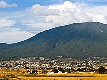
| Palacio Municipal , in the background the Xocotépetl | |
Coordinates: 19 ° 42 ′ N , 99 ° 47 ′ W
Jocotitlán (from Nahuatl Xocotitlan, "place between bittersweet fruits") is a municipality ( municipality ) in the northwest of the Mexican state of México . The municipality had 65.291 inhabitants at the 2015 census, the area of the municipality amounts to 86.9 km².
The administrative center and the most populous of the more than 50 places in the municipality is Jocotitlán , other larger places in the municipality are Santa María Citendeje , San Miguel Tenochtitlán , San Juan Cuajomulco and Santiago Casandeje .
The town
The town of Jocotitlán is located at the foot of the Xocotepetl volcano and near the towns of Atlacomulco and Ixtlahuaca . The center of the city has cobbled streets and buildings are mostly painted white with red roofs.
The social hub of the city is the plaza in the city center. In the upper area there is a pavilion in the middle of trees. Next to the plaza and the Jesús Nazareno (Jesus of Nazareth) church there is an indoor soccer field .
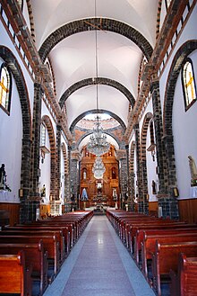
The parish church is named after Jesus of Nazareth and was built in 1575 and has since been expanded in three phases. The atrium cross dates from the 16th century and was built by the Franciscans . The current building was constructed in the 1860s with black sandstone and brick elements in a neoclassical style. The bell tower, on the other hand, was not completed until 1983, over 100 years later.
South of the plaza is the commercial center of Jocotitlán with the cultural community center "Casa de Cultura Lic. Diego de Nájera Yanguas". This is named after the former parish priest who published a book on the Mazahua language . The cultural center offers dance, painting and English language courses, among other things.
Further south, at the intersection between Jesus Cardozo and Rivapalacio streets, is the commune market hall. Mainly local goods and specialties are offered here, such as barbacoa , mole , quelites as well as local mushrooms, meat, escamoles and flowers.
geography
Jocotitlán is located in the northwest of the state of México, about 60 km north of Toluca de Lerdo . The municipality is located at an altitude of 2530 m on the Río Lerma to 3952 m at the summit of the Xocotépetl . Over 80 percent of the area of the municipality is used for agriculture.
The municipality of Jocotitlán borders the municipalities of El Oro , Temascalcingo , Atlacomulco , Morelos , Jiquipilco , Ixtlahuaca and San Felipe del Progreso .
The Xocotépetl is a stratovolcano and the highest peak in the immediate vicinity. It is considered potentially active as volcanic activity has been proven over the past 10,000 years.
The rest of the Jocotitlán municipality is flat and part of the Ixtlahuaca Valley. There are many ponds and smaller lakes such as Santa Elena, San Clemente, Hierbabuena, La Soledad, El Toril, Los Árboles, San Jacinto, Cuendo, La Redonda, La Gorupa and Pasteje. The fresh water source Las Fuentes supplies the fresh water for the community seat. The climate is considered to be subtropical, semi-humid with increased rain in the summer months. The annual mean temperature is 13.2 ° C with maximum values of approx. 31 ° C and minimum values around 4 ° C. At the end of December and the beginning of January there can be snowfall, especially on the Xocotépetl.
The vegetation consists mainly of pines , oyamels , holm oaks , cedars , eucalyptus and willows . In the lowlands there are mainly meadows and nopal cacti . There are also numerous wild herbs that are used in local cuisine and medicine.
Web links
- Enciclopedia de los Municipios y Delegaciones de México: Municipio Jocotitlán (Spanish)
- INEGI : Datos Geográficos: Municipio Jocotitlán (Spanish; PDF)
Individual evidence
- ↑ El bello pueblo de Jocotitlán (Estado de México). July 29, 2010, Retrieved October 5, 2019 (Spanish).
- ^ Francisco Estébanez, Jorge Arturo González, Gerardo Novo Valencia, Jorge de la Luz: The state of Mexico . 2nd Edition. Ediciones Nueva Guía, México 2002, ISBN 968-5437-26-2 .
- ↑ Jocotitlán. Retrieved October 5, 2019 .


