Municipio Tlatlaya
| Tlatlaya | ||
|---|---|---|

|
||
| Symbols | ||
|
||
| Basic data | ||
| Country | Mexico | |
| State | México | |
| Seat | Tlatlaya | |
| surface | 790.1 km² | |
| Residents | 32,997 (2010) | |
| density | 41.8 inhabitants per km² | |
| founding | 1849 | |
| INEGI no. | 15105 | |
| politics | ||
| Presidente municipal | Ariel Mora Abarca | |
Coordinates: 18 ° 36 ′ N , 100 ° 12 ′ W
Tlatlaya is a municipality in the Mexican state of México . The municipality had 32,997 inhabitants at the 2010 census, the area amounts to 798.92 km². The seat of the municipality is the Tlatlaya of the same name , while the largest of the 165 places in the municipality are San Pedro Limón and Santa Ana Zicatecoyan .
geography
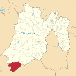
Tlatlaya is located in the extreme southwest of the state of México, about 120 km southwest of Toluca de Lerdo at an altitude of 300 m to 2400 m .
The municipality of Tlatlaya borders on the municipality of Amatepec and the state of Guerrero .
Web links
- Enciclopedia de los Municipios y Delegaciones de México: Municipio Tlatlaya (Spanish)
- INEGI : Datos Geográficos: Municipio Tlatlaya (Spanish; PDF)

