Municipio Nicolás Romero
| Nicolás Romero | |
|---|---|

|
|
| Basic data | |
| Country | Mexico |
| State | México |
| Seat | Villa Nicolás Romero |
| surface | 235.5 km² |
| Residents | 366,602 (2010) |
| density | 1,556.7 inhabitants per km² |
| Website | nicolasromero.gob.mx |
| INEGI no. | 15060 |
| politics | |
| Presidente municipal | Martín Sobreyra Peña |
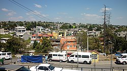
| Villa Nicolás Romero | |
Coordinates: 19 ° 38 ′ N , 99 ° 19 ′ W
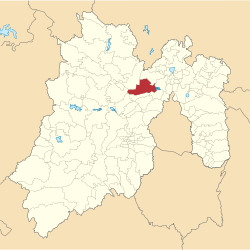
Nicolás Romero is a municipality in the Mexican state of México . It belongs to the Zona Metropolitana del Valle de México , the metropolitan region around Mexico City .
The municipality counted 366,602 inhabitants in the 2010 census, its area amounts to 235.5 km². The administrative seat and largest place of the municipality is Villa Nicolás Romero .
geography
Nicolás Romero is centrally located in the state of México, about 20 km northeast of Mexico City at an average altitude of 2370 m . About 40% of the municipality is used for agriculture or forested.
The Municipio Nicolás Romero borders the Municipios Villa del Carbón , Tepotzotlán , Cuautitlán Izcalli , Atizapán de Zaragoza , Isidro Fabela , Temoaya and Jiquipilco .
places
The municipality Nicolás Romero comprises 43 places, 13 of them have more than 2,500 inhabitants, 16 others at least 500 inhabitants. The biggest places are:
| Place name | Population (2010) |
|---|---|
| Villa Nicolás Romero | 281,799 |
| Veintidós de Febrero | 13,031 |
| Progreso Industrial | 11,289 |
| Quinto Barrio | 5,795 |
| Santa María Magdalena Cahuacan | 5,279 |
| San José el Vidrio | 5,204 |
| San Francisco Magú | 4,962 |
| San Miguel Hila | 4,373 |
Web links
- Enciclopedia de los Municipios y Delegaciones de México: Municipio Nicolás Romero (Spanish)
- INEGI : Datos Geográficos: Municipio Nicolás Romero (Spanish; PDF)

