Municipio of Ixtlahuaca
| Ixtlahuaca | ||
|---|---|---|

|
||
| Symbols | ||
|
||
| Basic data | ||
| Country | Mexico | |
| State | México | |
| Seat | Ixtlahuaca de Rayon | |
| surface | 337.2 km² | |
| Residents | 141,482 (2010) | |
| density | 419.6 inhabitants per km² | |
| founding | 1826 | |
| Website | www.ixtlahuaca.gob.mx/ | |
| INEGI no. | 15042 | |
| politics | ||
| Presidente municipal | Ángel Alberto Rebollo Montes de Oca | |
| Francis of Assisi Church in Ixtlahuaca | ||
Coordinates: 19 ° 34 ′ N , 99 ° 46 ′ W
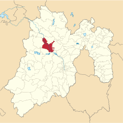
Ixtlahuaca is a municipality in the Mexican state of México . Cabecera des Municipios is Ixtlahuaca de Rayón . The municipality had 141,482 inhabitants in 2010, its area is 337.2 km² .
geography
Ixtlahuaca is located in the northwest of the state of México, 35 km northwest of Toluca de Lerdo. A predominant part of the municipality is used for agriculture.
The municipality of Ixtlahuaca borders the municipalities of San Felipe del Progreso , Jocotitlán , Jiquipilco , Temoaya and Almoloya de Juárez .
places
The municipality comprises 63 places, six of which have more than 5,000 and a further 24 more than 1,500 inhabitants. The largest place in the municipality is San Bartolo del Llano , ahead of San Pedro los Baños , Santo Domingo de Guzmán , Emiliano Zapata , La Concepción los Baños and Ixtlahuaca de Rayón .
Web links
- Enciclopedia de los Municipios y Delegaciones de México: Municipio Ixtlahuaca (Spanish)
- INEGI : Datos Geográficos: Municipio Ixtlahuaca (Spanish; PDF)


