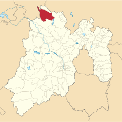
Municipio Aculco
| Aculco | ||
|---|---|---|

|
||
| Symbols | ||
|
||
| Basic data | ||
| Country | Mexico | |
| State | México | |
| Seat | Aculco de Espinosa | |
| surface | 455.1 km² | |
| Residents | 44,823 (2010) | |
| density | 98.5 inhabitants per km² | |
| founding | 1825 | |
| Website | www.aculco.gob.mx/ | |
| INEGI no. | 15003 | |
| politics | ||
| Presidente municipal | Salvador del Rio Martínez | |
| Capilla de El Senor del Pasito | ||
Coordinates: 20 ° 6 ′ N , 99 ° 50 ′ W
Aculco is a municipality in the Mexican state of México . The seat of the municipality is Aculco de Espinosa , the most populous place, however, San Lucas Totolmaloya before San Jerónimo Barrio and Gunyo Poniente . The municipality had 44,823 inhabitants in 2010, its area is 455.1 km² .
geography
Aculco is located in the north of the state of México, about halfway from Mexico City to Santiago de Querétaro .
The municipality borders the municipalities Jilotepec , Polotitlán , Acambay and Timilpan as well as San Juan del Río and Amealco de Bonfil in the neighboring state of Querétaro .
Web links
Commons : Municipio Aculco - collection of images, videos and audio files
- Enciclopedia de los Municipios y Delegaciones de México: Municipio Aculco (Spanish)
- INEGI : Datos Geográficos: Municipio Aculco (Spanish; PDF)


