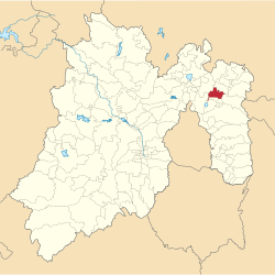
Municipio Acolman
| Acolman | ||
|---|---|---|

|
||
| Symbols | ||
|
||
| Basic data | ||
| Country | Mexico | |
| State | México | |
| Seat | Acolman de Nezahualcóyotl | |
| surface | 84.1 km² | |
| Residents | 136,558 (2010) | |
| density | 1,623.6 inhabitants per km² | |
| Website | www.acolman.gob.mx/ | |
| INEGI no. | 15002 | |
| politics | ||
| Presidente municipal | Vicente Anaya Aguilar | |
| Acolman Municipal Palace | ||
Coordinates: 19 ° 38 ′ 0 ″ N , 98 ° 55 ′ 0 ″ W.
Acolman is a municipality in the Mexican state of México . It belongs to the Zona Metropolitana del Valle de México , the metropolitan area around Mexico City . The seat of the municipality is Acolman de Nezahualcóyotl , with over 100,000 inhabitants, however, by far the largest place in the municipality is Tepexpan . The municipality had 123,024 inhabitants in 2010, its area is 84.1 km² .
The name Acolman comes from Nahuatl : acolli means water, and -maitl means "hand", thus roughly "place of the hand". The former Augustinian monastery is considered to be the origin of the Las posadas Christmas tradition .
geography
Acolman is located in the north of the state of Mexico, 52 km northeast of Mexico City.
The municipality borders on the municipalities Tecámac , Teotihuacan , Tepetlaoxtoc , Chiautla , Tezoyuca , Atenco and Ecatepec de Morelos .
Web links
- Enciclopedia de los Municipios y Delegaciones de México: Municipio Acolman (Spanish)
- INEGI : Datos Geográficos: Municipio Acolman (Spanish; PDF)


