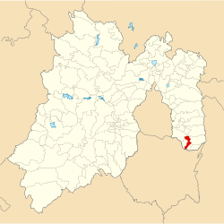
Municipio Ozumba
| Ozumba | ||
|---|---|---|

|
||
| Symbols | ||
|
||
| Basic data | ||
| Country | Mexico | |
| State | México | |
| Seat | Ozumba de Alzate | |
| surface | 46.2 km² | |
| Residents | 27,207 (2010) | |
| density | 588.6 inhabitants per km² | |
| founding | 1825 | |
| Website | ozumba.gob.mx | |
| INEGI no. | 15068 | |
| politics | ||
| Presidente municipal | Hugo González Cortes | |
Coordinates: 19 ° 2 ′ 21 ″ N , 98 ° 47 ′ 37 ″ W.
Ozumba is a municipality in the Mexican state of México . It belongs to the Zona Metropolitana del Valle de México , the metropolitan region around Mexico City .
The municipality had 27,207 inhabitants at the 2010 census, its area amounts to 46.3 km². The administrative seat and largest of the 16 towns in the municipality is Ozumba de Alzate with 16,700 inhabitants. Other places with more than 2,000 inhabitants are San Mateo Tecalco , San Vicente Chimalhuacán and Santiago Mamalhuazuca .
geography
The municipality is located in the south-east of the state of México at an altitude of about 2200 to 2700 meters. 90% of the area of the municipality is used for agriculture.
Ozumba borders the Municipios Tepetlixpa , Juchitepec , Amecameca and Atlautla as well as the state of Morelos .
Web links
- Enciclopedia de los Municipios y Delegaciones de México: Municipio Ozumba (Spanish)
- INEGI : Datos Geográficos: Municipio Ozumba (Spanish; PDF)


