Municipio of Ixtapan de la Sal
| Ixtapan de la Sal | ||
|---|---|---|

|
||
| Symbols | ||
|
||
| Basic data | ||
| Country | Mexico | |
| State | México | |
| Seat | Ixtapan de la Sal | |
| surface | 111.2 km² | |
| Residents | 33,541 (2010) | |
| density | 301.5 inhabitants per km² | |
| founding | 1822 | |
| Website | www.ixtapandelasal.gob.mx/ | |
| INEGI no. | 15040 | |
| politics | ||
| Presidente municipal | Ignacio Avila Navarrete | |
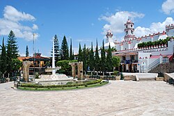
| Main square of Ixtapan de la Sal | ||
Coordinates: 18 ° 50 ′ N , 99 ° 41 ′ W
Ixtapan de la Sal is a municipality in the Mexican state of México . The municipality had 33,541 inhabitants in 2010, its area is 111.2 km² .
The administrative seat and largest place of the municipality is the eponymous Ixtapan de la Sal , the next largest places in the municipality are Tecomatepec , San Alejo and Ahuacatitlán .
geography
Ixtapan de la Sal is located in the south of the western part of the state of México, about 50 km south of Toluca de Lerdos at 1924 to 2020 m above sea level.
The municipality of Ixtapan de la Sal borders the municipalities Coatepec Harinas , Villa Guerrero , Zumpahuacán , Tonatico and Zacualpan, as well as the state of Guerrero .
Web links
Commons : Municipio Ixtapan de la Sal - Collection of images, videos and audio files
- Enciclopedia de los Municipios y Delegaciones de México: Municipio Ixtapan de la Sal (Spanish)
- INEGI : Datos Geográficos: Municipio Ixtapan de la Sal (Spanish; PDF)


