Municipio Tequixquiac
| Tequixquiac | ||
|---|---|---|

|
||
| Symbols | ||
|
||
| Basic data | ||
| Country | Mexico | |
| State | México | |
| Seat | Santiago Tequixquiac | |
| surface | 122.9 km² | |
| Residents | 33,907 (2010) | |
| density | 275.9 inhabitants per km² | |
| founding | November 29, 1820 | |
| Website | www.tequixquiac.gob.mx/ | |
| INEGI no. | 15096 | |
| politics | ||
| Presidente municipal | Salvador Raúl Vásquez Valencia | |
| Palacio Municipal of Tequixquiac | ||
Coordinates: 19 ° 54 ′ N , 99 ° 9 ′ W
Tequixquiac is a municipality in the Mexican state of México . It belongs to the Zona Metropolitana del Valle de México , the metropolitan region around Mexico City . The main office is Santiago Tequixquiac . The municipality had 33,907 inhabitants in 2010, its area is 122.9 km² .
The name
The name Tequixquiac comes from Nahuatl : tequixquitl means " saltpeter ", atl means "water" and -c means "place, place", Tequixquiac thus roughly "place of the nitric water".
geography

Tequixquiac is located in the north of the state of México, 84 km north of Mexico City. Tequixquiac as an orographic zone lies in the transition of the valley from Mexico to the depression of Mezquital. The municipality borders Apaxco to the north and west , Zumpango to the south, Huehuetoca to the southwest, and Hueypoxtla and Atotonilco de Tula in the state of Hidalgo to the east .
The maximum height of the municipality is 2,820 meters above sea level. Santiago Tequixquac is on average at 2,340 meters. The terrain consists of low rolling hills and small streams. The municipality is crossed by two canals, which take the rivers Río Grande and Xothe and flow into the Salado.
There are four artificial reservoirs within the municipality:
- Dolores dam, which stores the waters of the canals,
- Bermejo dam, which collects precipitation from the surrounding hills,
- Salto Dam is located in the city of Tlapanaloya and
- Xocoyol Dam in the Apaxco Gorge .
The area has 28 intermittent streams that fall dry at times, nine deep wells and eleven pumps to natural springs.
history
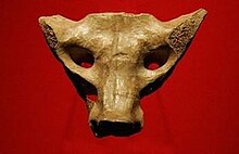
Archaeological finds show that the area was settled 35,000 years ago by immigrants who had come from Asia via the Bering Strait. One of the most important finds is called Hueso Sacro de Tequixquiac ( sacrum of Tequixquiac ), which was carved 22,000 years ago. The first settlers of Tequixquiac were ( Aztecs and Otomí ), who settled in this place with many rivers and springs and mainly practiced agriculture and livestock. Tequixquiac comes from a Chichimean settlement that can be traced back to the 2nd century and was raised to an independent municipality on March 2nd, 1552.
The Saint James Apostle Church was built in several phases. There are fountains in each of the four corners of the vestibule, and in the middle there is an open space with Solomonic columns. The facade has two doors, the stone surrounds of which are decorated with indigenous symbols. The temple and the city are dedicated to the apostle James. During a drought, a sculpture of Señor de la Capilla ( Our Lord of the Chapel ) was brought from Apaxco to Tequixquiac. She stayed in the city ever since and has been credited with many miracles. The parish was built in 1856.
During the Porfiriat the drainage tunnels for the Valley of Mexico were built to relieve the severe flooding that has occurred there since ancient times. They were built by engineer Francisco Garay under the direction of Miguel Iglesias. On February 4, 1870, under the direction of the engineer Tito Rosas, the sacrum was found in the Tequixquiac excavation at a depth of twelve meters. The tunnel project was completed on March 17, 1900 and inaugurated by Porfirio Diaz.
Unplanned urbanization began to spread in Tequixquiac from the middle of the 20th century. The reason for this was land speculation by the government authorities of the state of Mexico, which the ex-governor Arturo Montiel Rojas had initiated through the company Wilk SA.
On July 5, 2009, a woman won the mayoral elections of Tequixquiac for the first time: Xochitl Ramírez Ramírez took office on October 1, 2009.
population
| year | Residents |
|---|---|
| 1990 | 20,784 |
| 2000 | 28,039 |
| 2010 | 33,907 |
Tequixquiac had a population of 33,907 in 2010.
Biggest places
| Cities | Residents |
| local community | 33,907 |
| Santiago Tequixquiac | 22,676 |
| Tlapanaloya | 6,466 |
| San Miguel | 2,754 |
| Wenceslao Labra | 1,248 |
Culture
architecture

The St. James the Apostle Church was built in several stages. The atrium was a large room enclosed in stone with a cross on top, but with Christian and indigenous symbols on the walls. There are fountains in each of the four corners, and in the middle there is an open space with Solomonic columns. The facade consists of two doors that are ornately decorated in stone that contains indigenous symbolism. The church and the city are dedicated to the Apostle James.
people
Alexander von Humboldt visited and researched the indigenous pueblos in 1804, and Porfirio Díaz inaugurated a canal in this area in 1900.
Fortino Hipólito Vera y Talonia was bishop of Cuernavaca .
literature
- Bando Municipal de Policía y Buen Gobierno . 1999.
- Monografía Municipal de Tequixquiac . Rodríguez Peláez María Elena, 1999.


