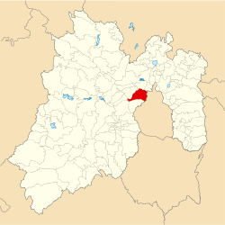
Municipio Naucalpan de Juarez
| Naucalpan de Juarez | ||
|---|---|---|

|
||
| Symbols | ||
|
||
| Basic data | ||
| Country | Mexico | |
| State | México | |
| Seat | Naucalpan de Juarez | |
| surface | 157.6 km² | |
| Residents | 833,779 (2010) | |
| density | 5,290.8 inhabitants per km² | |
| founding | January 1, 1826 | |
| Website | naucalpan.gob.mx | |
| INEGI no. | 15057 | |
| politics | ||
| Presidente municipal | David Ricardo Sánchez Guevara | |
| The town hall of Naucalpan de Juárez | ||
Coordinates: 19 ° 29 ′ N , 99 ° 14 ′ W
Naucalpan de Juárez is the third largest municipality in terms of population in the central Mexican state of México after Ecatepec de Morelos and Nezahualcóyotl . It belongs to the Zona Metropolitana del Valle de México , the metropolitan region around Mexico City .
In the 2010 census, the population of Naucalpan de Juárez 'was 833,779 people, the area of the municipality amounts to 157.6 km². The administrative seat and most populous city in the municipality is the eponymous Naucalpan de Juárez .
Geography and location
Naucalpan de Juárez is centrally located in the state of México at an altitude of about 2200 m to 3650 m . Phaeozem and Vertisol are the predominant soil types. The Los Remedios National Park is located in the municipality .
The municipality of Naucalpan de Juárez borders the municipalities Jilotzingo , Atizapán de Zaragoza , Tlalnepantla de Baz , Huixquilucan , Lerma and Xonacatlán as well as the federal district of Mexico City .
Places and structure
According to INEGI, the municipality of Naucaplan de Juárez includes 58 localities, five of which have a population of more than 2,500 people. In addition to the administrative headquarters in Naucalpan de Juárez , these are also San Francisco Chimalpa , Ejido de San Francisco Chimalpa , Santiago Tepatlaxco and San José Tejamanil .
The municipality is divided into four zones: the zona popular , the zona residencial , the zona rural and the zona industrial .
Sports
As part of the 1968 Summer Olympics in Mexico City , the community was the venue for road cycling competitions . The so-called Satellite Circuit was a very hilly 24.525 km long circuit. This led, among other things, on the Boulevard Manuel Ávila Camacho , a main road in the northern district of Ciudad Satélite . The Torres de Satélite are also located here .
Web links
- Enciclopedia de los Municipios y Delegaciones de México: Municipio Naucalpan de Juárez (Spanish)
- INEGI : Datos Geográficos: Municipio Naucalpan de Juárez (Spanish; PDF)
- Official website


