Municipio Zinacantepec
| Zinacantepec | ||
|---|---|---|

|
||
| Symbols | ||
|
||
| Basic data | ||
| Country | Mexico | |
| State | México | |
| Seat | San Miguel Zinacantepec | |
| surface | 309.9 km² | |
| Residents | 167,759 (2010) | |
| density | 541.3 inhabitants per km² | |
| founding | 1826 | |
| INEGI no. | 15118 | |
| politics | ||
| Presidente municipal | Olga Hernández Martínez | |
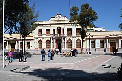
| Palacio Municipal | ||
Coordinates: 19 ° 17 ′ N , 99 ° 45 ′ W
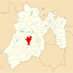
Zinacantepec is a municipality in the Mexican state of México . It belongs to the Zona Metropolitana del Valle de Toluca , the metropolitan area around Toluca de Lerdo . The seat of the municipality is San Miguel Zinacantepec . The community had 167,759 inhabitants in 2010, its area is 309.9 km² .
geography
Zinacantepec is located in the center of the western part of the state of México, about 8 km west of Toluca de Lerdo. Zinacantepec is located on the highest meseta in the country at an altitude of 2750 m to 3200 m . A good half of the community area is used for agriculture.
The municipality of Zinacantepec borders on the municipalities Almoloya de Juárez , Toluca , Coatepec Harinas , Temascaltepec and Amanalco .
towns and places
The municipality comprises 56 places, 8 of which have over 5,000 inhabitants, another 29 at least 500 inhabitants. The largest places in the municipality are:
| Place name | Population (2010) |
|---|---|
| San Miguel Zinacantepec | 54,220 |
| San Antonio Acahualco | 16,442 |
| San Juan de las Huertas | 12,253 |
| Ejido San Lorenzo Cuauhtenco | 8,024 |
| Santa Cruz Cuauhtenco | 7,460 |
| Barrio de México | 7,414 |
| Conjunto Urbano La Loma I. | 6,192 |
| El Cóporo | 6,068 |
| Santa María del Monte | 3,922 |
| La Joya | 3,800 |
| San Bartolo el Viejo | 3,312 |
| Colonia Morelos | 2,915 |
| Tejalpa | 2,729 |
Web links
- Enciclopedia de los Municipios y Delegaciones de México: Municipio Zinacantepec (Spanish)
- INEGI : Datos Geográficos: Municipio Zinacantepec (Spanish; PDF)


